|
|
The Bridging Of The Tyne & Tweed
|
THE BRIDGING OF THE RIVER TYNE
The river Tyne geographically is the
gateway of the sea for Northumberland
and Durham. This was especially true
centuries ago before the arrival of
railway trains and road haulage
transport. The Baltic and Scandinavian
trade was an important source of
revenue to those Counties. The ideal
way for the traders to transport their
products was by sea, hence the need
for the river Tyne as a vital route.
The cities of Newcastle and Gateshead
sprung up on the banks of the Tyne. It
was certain that the river was their
reason of origin at the part of the
Tyne the most easy to bridge and
because of its closeness to the sea.
It may surprise many people to learn
that the first bridge across the Tyne
was built some nineteen hundred years
ago, approximately 120 AD. The great
Emperor Titus Aelius Hadrianus ( more
commonly known as Hadrian ), at that
time head of the mightiest army in the
world and of the great Roman Empire,
gave orders to bridge the Tyne at
Newcastle, ( or Monkchester as it was
then known ). The Emperor was leading
a warlike expedition to the very
limits of the vast Roman empire. The
bridge, a wooden superstructure on
stone piers, played a vital part in
the building of the Roman Wall. The
wall was to serve as a barrier to keep
out the marauding Northern tribes.
The Romans actually built three
bridges during their 400yrs occupation
of the North. The first of course on
the site which is now occupied by the
Swing Bridge at Newcastle, the second
at Corbridge, the third at Chesters.
For over three centuries the Roman
armies held that wall and their Tyne
Bridge against the Northern threat.
This allowed the part of Britain to
the South of the wall to develop
peacefully as a civilisation. The
Romans of course created open trade
and easy communication, especially in
the building of roads. They also
created an organised society, with
just laws for all, and perhaps most
noteably, a long established period of
peace. It was a peace which extended
across the world and one which it was
hoped would endure. Sadly the long
years of peace and prosperity brought
apathy and a weakness in the qualities
of the Roman people themselves. This
was the beginning of the end of the
centuries of peace and harmony. With
Rome in turmoil due to a power
struggle, the warlike tribes of
Germany and the North, took full
advantage of the situation and
attacked even Rome itself.
In around 410 A.D. the Romans withdrew
their forces from Britain, with the
city of Rome in danger the might of
the army was needed to defend its own
territory. Once the Romans left,
Britain was unable to defend itself.
The Northern area was in the worst
predicament, Hadrians Wall was over-
run and the barbarous Northern tribes
poured over the Tyne Bridge.
For six centuries of the Anglo Saxon
period, there is no evidence of a
bridge spanning the Tyne. It is
probable that the Picts and Scots
plundered Hadrians vacated camps, and
immediately destroyed the Roman bridge
which had been named " Pons Aelii ".
If the bridge had remained it would
have seen the horrific and terrifying
sight of Danish and Anglian ships full
of warriors sailing up the Tyne. At
first to loot, plunder, and kill, then
eventually, to invade the lands,
conquering and settling in this
Country. Once quiet returned in
Anglian Northumbria, the bridge, if
bridge there was, would certainly have
been crossed by the Missionaries St
Cuthbert and St Aidan. Later to be
crossed by the ‘Venerable Bede ' on
his way from his Jarrow Monastery to
visit Monkchester, as Newcastle was
called then.
With the arrival of William the
Conqueror in England, the North was
once more to see instability.
Northumbria opposed his rule so
strongly, that Williams large army
engaged in "The Harrying of the
North". It is believed that Hadrians
bridge was rebuilt once more of wood
but supported on the original Roman
piers, in or around the year 1080,
when the "New Castle" of William the
Conqueror's son Robert was built. With
an important Norman Castle and a
bridge below it across the Tyne,
border raids and the Scottish wars
meant regular assaults on Newcastle.
There were reputed to be over forty
four routes used by predators, for
three hundred years these routes were
guarded constantly. Beacons were
erected to act as warning if raiders
from the borders attacked, it was an
insecure period for the inhabitants.
The wooden bridge built by the Normans
was destroyed by fire in 1248, and a
medieval bridge was erected on that
same site. Newcastle Corporation paid
two thirds of the cost on the Northern
side, with the Bishop of Durham
covering the remaining costs on the
South side. That Bridge made of stone
stood until 1771, in 1339 when less
than ninety years old, the bridge
suffered severe flood damage with the
loss of 120 lives, but still stood. In
1370, once again extensive repairs
were required due to erosion, but
still the bridge survived, many years
later the bridge was not to be so
lucky.
The river Tyne was a natural barrier
between Northern and Southern England,
as well as denying access to Scotland.
Over the years the Tyne was bridged
many times. Indeed at one time there
were seven bridges spanning the Tyne,
only a matter of a few hundred yards
apart. The vital link to the North,
for not only road haulage but for rail
link, was given high priority by
successive Governing bodies. This lead
to bridges being built not only at
Newcastle, but also at Scotswood in
1831. The bridge at Corbridge had
survived the terrible flooding of 1339
and 1771.
In almost quick succession, bridges
were built to span the Tyne between
Newcastle and Gateshead. The High
Level in 1849, The first Redheugh in
1871, The Swing bridge in 1876, the
second Redheugh in 1901, the King
Edward in 1906, The New Tyne in 1928,
the New Redheugh in 1981, and the
Queen Elizabeth 2nd, (Metro Rail),
1977.
Emperor Hadrian was the first person
to realise the need for a bridge over
the Tyne linking North to South. Over
the centuries that link has never
diminished in importance, at the time
of writing, no less than six bridges
span the river between the two cities.
|
|
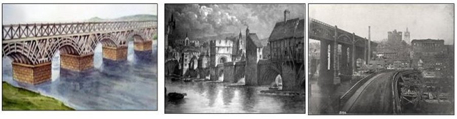
Pons Aelius (pictured above left)
The first bridge known to have crossed the Tyne (called the Tinea by the Romans) was built in the reign of the Roman Emperor Hadrian at the time of the Roman Wall which passed through what is now Newcastle. The bridge was called Pons Aelius or Bridge of Aelius after Hadrian's family name and the town which grew up here may also have been of that name. The fort built here guarded the crossing on the Tyne and the original eastern end of Hadrian's Wall, the bridge linking the fort of Congangis (at Chester-le-Street) to this fort.
The piers of the Roman bridge were used to support the medieval bridge or bridges which followed it. The Roman bridge would be manned and guarded against enemies of Rome and lasted until the Roman withdrawal from Britain in the 5th century. Roman ships used the Tyne and no doubt supplies and soldiers and civilians reached the Roman settlements in the north by sea, sailing to the important fort at South Shields called Arbeia, quite close to Wallsend at the wall's eastern end. Roman settlements further south would also be linked to the new base on the Tyne via the bridge. It may have been repaired at various times long after the Romans left and the site was at or near the present Swing Bridge.
The Old Stone Bridge (above centre)
When the wooden built Norman bridge was destroyed by fire in the year 1248, it was essential that it was replaced as quickly as possible. The Officials of Newcastle Corporation and the Bishop of Durham reached agreement on the financial arrangement. The Corporation had taken the view that the Southern side of the river needed a bridge just as much as the Northern side. It was agreed that they were to pay the Northern contribution of two thirds, the Bishop of Durham paying the remainder.
Around the year 1250 the new bridge was built, this was of stone and expected to stand for centuries. It was an enormous structure, about 711ft. long and 15ft. wide. with eight arches. Shops and houses were built on it, along with a Chapel to Thomas a Beckett the Martyr. There also stood a Prison Tower, probably because escape from it would have been very difficult, standing above the water as it did. It was very picturesque and always a hive of activity, with its own houses and forming their own community.
In the year 1339 disaster struck, floods crashed into the structure of the bridge itself causing great damage, the bridge was not yet ninety years old. More than one hundred people were drowned in and near Pandon Dene, one hundred and forty houses were totally destroyed. Thankfully the bridge survived and was repairable, it was to last for a number of centuries yet. Unfortunately in 1370 due to erosion the Bridge once more required large scale repairs. Following those repairs the bridge stood upon twelve arches, although in later years three of those arches were turned into cellars at the building of the Quays, this left nine arches.
As one would expect, many famous people were to cross this 'gateway to the north'. In 1503, Margaret, the daughter of King Henry V11, passed over it, on her way North to marry James 1V of Scotland. It was a political marriage, designed to end the hostility between the two countries. It was to lead to the unification of the Crowns one hundred years later when James V1 of Scotland, became James 1 of England, he also crossed the bridge on his way to the English Throne.
In 1771 the bridge was destined to be battered by floods far worse than those of 1339, this time however it would lead to its final destruction. During the night between Saturday 16th November and Sunday 17th November, the river rose to over nine feet above the high water spring tides, filling most of the arches of the bridge. The Close, Sandhill, and Quayside were deep under water, ships floated clear of their mooring and onto the Quayside roadways. They stayed there when the floods eventually did subside, and presented the very serious problem of how to get some of those huge ships back into the water. The shores on both sides of the river were submerged under water, a graveyard was swamped to the extent that some bodies were exhumed and went floating off down the river.
Early on the Sunday morning the middle arch of the bridge crashed down, in the afternoon a second and third arch were so badly damaged that they too eventually fell. With the bridge so damaged, the surging tides caused more and more havoc, erosion took place at an unbelievable rate. It was eventually beyond repair and totally demolished.
The Wooden Bridge (pictured above right)
The floods of 1771 were disasterous, further up river the only bridge to survive was that at Corbridge. There was again the obvious need to raise yet another bridge across the river between Newcastle and Gateshead. A temporary wooden bridge was designed and erected by one John Stevenson, at the same time a ferry carried stagecoaches and other heavy loads across the river. In about 1773 a stone bridge with nine great arches was built on the same site as that of the ill fated Roman and Medieval Bridges. The span of the arches varied from 27ft. to 57ft. and the bridge itself was 21ft. wide, later increased to 35ft. It was completed in 1779, and a toll charge was levied to pay for its upkeep, in 1801 it was widened by David Stephenson. In approximately 1819 gas lamps appeared on the bridge, gas having first been used in Newcastle to light Mosely Street in 1818.
This Bridge stood for only 95yrs before being replaced by the new hydraulic Swing Bridge in 1876.
|
|
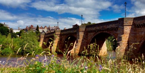
CORBRIDGE - ROMAN BRIDGE
LELAND (1540) recorded that "The Stone Bridge that now is at Corbridge over Tine is larg, but it is set somewhat lower apon Tine than the old Bridge was. There be evident Tokens yet seene where the old Bridg was and thereaboute cummith downe a praty Broke on the same side that the Town is on." He is clearly referring to the Roman bridge which carried the road to Corstopitum.
In dry summers the south abutment and two of the ten piers are still visible. The piers were 15 feet wide and 29 feet long, pointed on the upstream and flat on the downstream face, the roadway was in wood. The stones of the piers were removed in 1840 to build the water mill at Dilston.
The Roman Bridge above Corbridge disappeared during the Middle Ages and the ford across the river was a quarter of a mile below the present bridge. The ford was approached from the north by a lane leading from the Newcastle road at the east end of Main Street. The next bridge at Corbridge was built in 1235. In 1298 royal officers went to Corbridge to purchase horseshoes and nails, and the tariff imposed to raise money for upkeep of the medieval bridge included tolls on nails of different kinds, horseshoes, cartwheel-sheaths, griddles, iron cauldrons and vats.
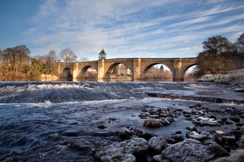
The bridge was the great asset of the town. Described in 1306 as the only bridge between Newcastle and Carlisle, it was maintained also as a link between England and Scotland. In 1674 it was replaced by the seven-arched bridge we see today. So well did the builder of this bridge execute his contract that his was the only one on the Tyne to withstand the famous flood of 1771. In 1881 it was widened by three feet but its appearance was not spoilt.
Tradition says that a man called Johnson was the builder and that during its erection one man had a penny a day more than the other workmen, his duty consisted in filling every crevice and opening with hot running lime, so that the whole became one solid mass.
|
|
CHOLLERFORD BRIDGE
Chollerford is a village in Northumberland, England. It is situated approximately four miles (seven km) to the north of Hexham (via the A6079 road) on the B6318 road, not far from Hadrian's Wall. There is a roundabout in the village where the B6318 and B6320 roads meet, and the traffic light-controlled Chollerford Bridge crosses the River North Tyne.
This is the first bridge on the North Tyne and is another old stone bridge, listed, and replacing a medieval one damaged in the flood of 1771. It is situated on the B6318 road, known locally as the Military Road as it was built 8 years after the Jacobite rebellion of 1745 to provide easier movement of troops between Newcastle and Carlisle. Robert Mylne was the engineer. At the bottom of a steep and winding descent down Brunton Bank. In 1958 a lorry ran downhill and demolished part of the parapet on the northeast side of the bridge, and shedding its load. The carriageway was narrowed for one-way traffic in 1976 and lights installed. While later repairs were carried out a temporary Bailey Bridge was provided. The crossing is narrow and there is a division of routes on the far side, up the Tyne to Bellingham or Humshaugh or west towards Carlisle, continuing along the military road. A weir is located downstream of the bridge which is Grade 2 listed.
The Border Counties Railway ran alongside the river on the east side with a station , now a private house, on the river bank, while on the west side stands the old George Hotel, where literary giants W H Auden and John Steinbeck have both stayed.
Facts: Constructed – 1775, Type – arch, 5 semicircular stone arches, total span 90 metres.
Position – Chollerford, Northumberland
Grid Ref. – NE919 705
|
|
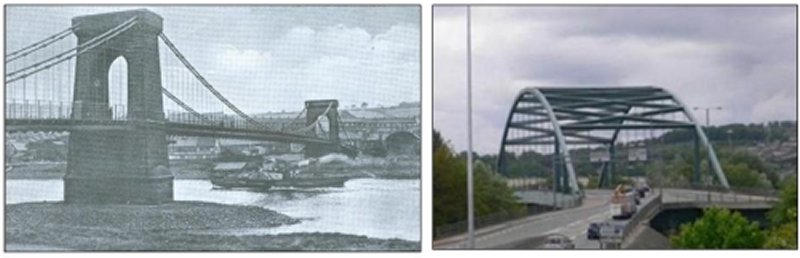
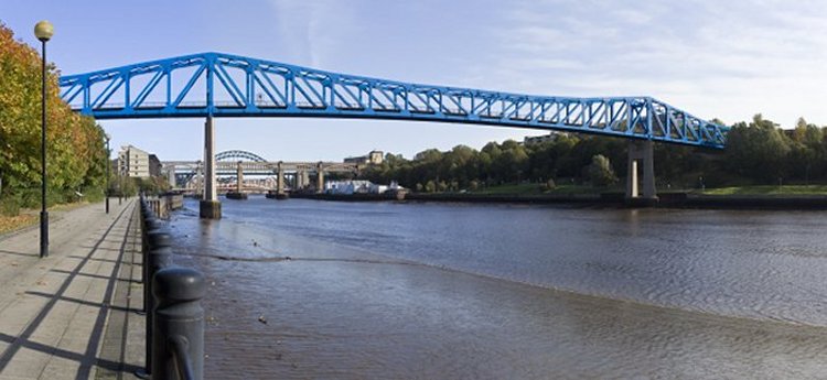
SCOTSWOOD SUSPENSION BRIDGE (pictured above left)
It was Rector Charles Thorpe of Ryton who first thought of a scheme to build a bridge across the Tyne in between Scotswood and Lemington. Interested parties met on 23rd December 1827 in the " Stella Staith Inn " to discuss the possibilities of building a bridge to connect with the Turnpike Road from Gateshead to Hexham. The meeting was attended by Messrs Dunn, Hodgson, Carr, Silvertop, Humble, Matthews, Lamb, and of course Rector Thorpe. All present after much discussion voted to begin the process of building a bridge.
On the 29th February 1829 a petition was presented to Parliament asking for a Bill to put the scheme of building a Toll Bridge into motion. A joint Stock Company had already been formed, the petition was granted Royal assent on 13th April 1829, the Stock Company then became the Scotswood Bridge Company. On the 21st April 1829 the first stone was laid on the Blaydon side of the river under the direction of the Architect, Mr John Green of Newcastle.
Work began to progress, but unfortunately during the night of the 13th October 1829 the River Tyne was dramatically swollen by prolonged and torrential rain. The surging water carried before it the existing scaffold and timbers, some swept as far as Swalwell. The Derwent too had burst its bank in several places and rushed through Swalwell causing untold damage. When the rain stopped and the waters subsided workmen travelled out to collect in their lost materials. It was a long and painstaking job, but once more work began on the Bridge.
The first chain to be suspended across the river was put in place on the 23rd February 1831, the last one, on the 5th March. The bridge took over two years to build, cost £15,000 and was completed on the 16th April 1831. It was one of the first chain suspension bridges in the world, the two piers were built in Norman style architecture. The total length of the bridge was 670ft, the distance between the points of suspension was 370ft, with two half arcs of 130ft. There were four suspending chains, each consisting of four flat bars in ten feet lengths. These were coupled together with five plates, eight inches broad and one inch thick, with strong connecting bolts. The road across the bridge rose in the centre approximately seven to eight feet, this assumed a curved line.
The bridge was officially opened on Tuesday 16th April 1831. A long procession headed by the Lord Mayor set out from Newcastle in a carnival atmosphere. The High Sheriff of County Durham, Charles Clavering, met them at the new bridge and escorted them across into his County. The Rector Thorpe performed a service of dedication in the centre. When the bridge was declared open to all users some five to six thousand people swarmed onto it, the bridge held firm, tried and tested.
Newcastle Corporation bought the bridge in 1905 for the sum of £36,000, part of the cost being met by the two County Councils and Gateshead Corporation, it was then freed from its tolls.
THE NEW SCOTSWOOD BRIDGE
By 1921 it was inevitable that motorised traffic would increase greatly, especially the company and family car. The Suspension Bridge had never been designed to cope with such a high density of traffic, so thoughts turned toward a new bridge. Due to an economic slump in 1931, the authorities had for the time being to shelve their intention to build a new bridge, instead they had the existing one improved. It was widened and the chains replaced by thick wire hawsers which were passed over the tops of the towers rather than through them. Footpaths were added with side parapets for the many pedestrians.
As soon as the money became available the decision was taken to build a new Scotswood Bridge and demolish the existing one. There followed a campaign to try to save the old bridge, its historical importance was stressed, the fact that it was the first four chain suspension bridge anywhere in the world. Unfortunately the planners and relevant authorities were unmoved, even the suggestion that a part of it be preserved was rejected. The Scotswood Suspension Bridge was closed for demolition in March 1967.
|
|
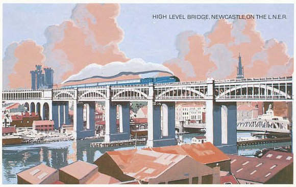
THE HIGH LEVEL BRIDGE
By 1839 Newcastle was linked by rail to Carlisle and the first railway bridge was built at Scotswood. In 1844 Gateshead at Redheugh was connected by rail with Darlington, whilst another line joined Newcastle with Berwick. Unfortunately, connection between these lines had to be made in an awkward roundabout journey via Scotswood. It was obvious that a railway link between Gateshead and Newcastle was needed as a matter of urgency.
The concept of a high level bridge between Newcastle and Gateshead was originally the idea of a Master Mason of Newcastle, Mr Edward Hutchinson. He had suggested it to the Corporation following the total demolition of the Old Tyne Bridge in 1771, unfortunately no action was taken. An alternative idea had been brought forward in 1833 for an elevated suspension bridge by a Civil Engineer Mr B.R.Dodd. In 1839 John and Benjamin Green aided by Richard Grainger made alternative suggestions. But a local eccentric, William Martin was the first to think of a road and rail bridge combined. His idea was eventually to be accepted, albeit a few years later, but Martin was never credited with his original idea by the Authorities. It was John Dobson, the famous Newcastle Architect who put forward a comprehensive plan for a road and rail bridge. Probably because of his fame, the plan received serious consideration by the Directors of the Newcastle Carlisle Railway Company. They accepted the design and engaged the services of the great Engineer Robert Stephenson, (son of George). Stephenson was to carry the scheme into fruition, Dobson was to be the Designer.
Construction began in 1846 and ended in 1849. Stephenson was ably assisted by fellow Engineer Thomas Eliot Harrison. The bridge consists of six cast iron arches of 125ft. each supported on piers of masonry. To reduce the weight as much as possible, the tall stone piers were built hollow from just above high water mark. The total length of the bridge is 1,337ft. and the height from high water to the carriageway is 85ft. Approximately 5,000 tons of cast and wrought iron were supplied by Hawks, Crawshaw and Co. of Gateshead, and Losh Wilson and Bell of Walker. The difference between the two metals being that cast iron is used in that condition, as cast, whilst wrought iron is rolled to establish a grain.
The first ' test train ' weighing 200 tons passed over the Bridge in August 1849, the lower road deck was opened to pedestrians in February 1850. The whole project had cost almost half a million pounds. It was hailed as one of the Engineering wonders of the world.
The Bridge was officially opened by Queen Victoria on the 28th September 1849.
|
|
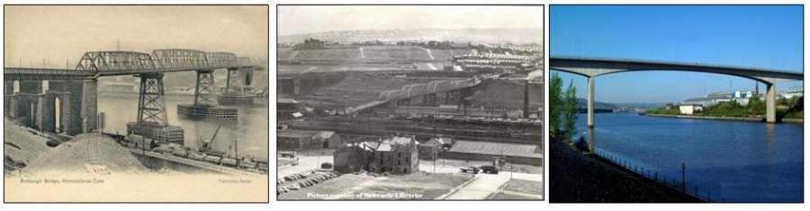
THE REDHEUGH BRIDGES
There have been three Redheugh Bridges, the first in 1867 was designed by Thomas Bouch, he had designed the ill fated Tay Bridge. It is perhaps a mystery that Bouch was selected to design any other bridge when his first effort collapsed.The Tay (railway) Bridge was two miles long and opened in 1878. On December 28th 1879 more than half a mile of the bridge, with a train on it, was blown down in a violent gale, seventy people lost their lives. An official inquiry revealed that the wind pressure was in excess of 40lb per sq. ft., but the bridge was designed to cope with only 12lb.
THE FIRST REDHEUGH BRIDGE (pictured above left).
Three river piers were founded on iron cylinders sunk pneumatically on to gravel 60ft below high water and filled with concrete. Stone pillars supported cast iron bed plates, which in turn carried four columns braced with horizontal and diagonal bracing. Clear spans of 240ft in the centre openings and 160ft side openings were bridged with trussed girders, the top member on each side of which was a 27in. diameter iron tube. The main trough girders carried two watermains and the top members carried town gas.
A toll house was present on the Newcastle side of the Redheugh Bridge when it opened in 1871 however, revenue was not as high as expected. The toll house also re-opened when the second Redheugh Bridge was built in 1901 and after WW1 the volume of traffic over the bridge increased greatly aiding toll revenue. However, with the opening of the toll free Tyne bridge in 1928 the Redheugh Bridge noticed a drop in tolls and it was suggested they accept an offer made by the Corporations of Newcastle and Gateshead to sell the bridge for £151,000. The Redheugh Bridge was sold in 1937 at which time the tolls were
An interesting feature of Bouch's design was the provision at each pier position of a pair of 64ft high towers from which suspension bars extended to the third points of each main river span and for a similar distance along each shore span. Although Bouch's intention is not clear the bridge had the form of a modern cable stayed structure. It was designed to a uniformly distributed live load of 100 lb/square foot.
In 1889 Sir John Fowler was asked to report on Bouch's bridge and his partner, Benjamin Baker, made a personal examination of the structure. He detailed the condition of the fenders, masonry piers, and iron superstructure. Apart from the need for remedial work to the piers, Baker had given a favourable report, noting that the superstructure had sufficient strength to support the highway deck, which had grown from an inch of stone grouted with asphalt to nearly six inches of tar paving.
Four years later, in November 1893, Mr J.Watt Sandemann was appointed Engineer to the Redheugh Bridge Company, and with his partner Moncrieff, he reported to the Company that the cross girders needed repairs, that the iron piers were inadequately braced against wind loads, and the safe loads for vehicular traffic were 6 tons on four wheels or one and a
half tons per wheel until the cross girders were repaired. In its present condition additional water mains required, could only be located on the footways. Estimated costs for repairing the bridge, piers, and installing new water pipes amounted to £22,815.
The report was submitted for the views of an eminent Civil Engineer, Mr Barlow. Sir Alex Rendel and Professor Fowler were mentioned but for some reason Sir Benjamin Baker was specifically excluded.
In the event the opinion obtained was from J. Wolfe Barry and Company, who recommended that a new bridge should be built. The existing bridge failed completely to meet the stringent requirements of the Board of Trade. The Board went back to Sir Benjamin Baker, they reminded him that in 1889 he had made a joint report with Sir John Fowler, certifying that the bridge was in good order. Consultations between Baker and Barry followed and a further site inspection took place. Baker then confirmed, that both the original construction and the effects of poor maintenance were much worse than appeared from his previous inspection. The Board of Trade Officials were now more conscious of the unsatisfactory standard of safety in general. It may be that the Tay Bridge disaster which took place in 1875 had caused alarm in Government circles. The report of J. Wolfe Barry and Company was accepted, the decision was taken to replace the existing bridge.
THE SECOND REDHEUGH BRIDGE (pictured above centre)
Sandemann and Moncrieff of Newcastle upon Tyne designed a replacement bridge in 1897 with two channel spans of 248ft and two shore spans of 148ft. The carriageway was 20ft wide with two 7ft wide footpaths. Construction completed in 1901, took place without cessation of pedestrian traffic and a minimum interruption to vehicles. The new foundation cylinders 8ft in diameter were sunk under compressed air with the use of external kentledge, near to the old cylinders, but to a much greater depth. The lattice trusses had N-bracing, intermediate struts and posts, and unlike its predecessor, overhead wind bracing, with gas and water pipes at deck level. The girders were built parallel to the old bridge girders, and above them, allowing traffic to continue until the old bridge spans were removed and the new ones lowered by hydraulic jacks on to their bearers and then slid laterally into position. The new bridge works cost £82,000.
Shortly after completion of the bridge, settlement on the south bank, where Bouch's bridge had also shown movement, led to measures being taken to strengthen the masonry piers. These were tied together but their longitudinal stability remained suspect, a factor of importance as traffic changed from horses and carts to heavy lorries with increasing braking capacity.
On May 10th 1937 the bridge passed into the joint ownership of the two County Boroughs of the City of Newcastle upon Tyne and Gateshead at a cost of £115,000. In 1951 woodblock paving on the main spans was replaced by asphalt and in 1965 the stone setts of the approach span road were also replaced by asphalt. In 1964 welding repairs to the ends of the kerb stringers and to deck cross girders were carried out. However, an inspection in 1968 caused great concern and indicated a very short life expectancy.
By 1973 corrosion of both the main bridge and the northern approach was again causing concern. At this time the fatigue life of various members was first considered. An estimate of the major loading cycles from 1901 to the first firm records in 1965 was projected forward into the future and gave indications of stringer failure at the fixed ends in 1980.
Tyne and Wear County Council, which had inherited responsibility for highway and bridge maintenance in April 1974, carried out further repairs in 1974/75. In an attempt to extend fatigue life until 1995, heavy loads were reduced in July 1976 by banning all vehicles over 3 tons gross weight except for buses, police, and emergency vehicles. A further inspection by Tyne and Wear Engineers in March 1978 showed increasing corrosion damage extending into the buckle plates between the stringers. The road lacked positive drainage and road salt was having its inevitable effect upon a structure which also spanned sea water. It appeared that the life of stringers could not be prolonged beyond 1983, redecking would be expensive and would require closure of the bridge for 18 months.
The bridges over the Tyne in the central zone (Newcastle and Gateshead) provided only five traffic lanes in each direction, and the temporary loss of a single lane causes traffic jamming at peak hours. Additionally the inability of the existing Redheugh Bridge route to carry double-deck buses and other high vehicles severely limited flexibility in the re-routeing of traffic to meet emergencies on the other bridges. The total closure of Redheugh Bridge for 18 months was difficult to contemplate, even if an element of relief could be expected when the Queen Elizabeth 2nd Bridge was carrying passengers by Metro.
Only by removing the vehicles which now contribute most to the fatigue damage, the single-deck buses, could the life of the bridge be extended to the point at which a replacement could be ready. The decision was difficult, because as a matter of public policy bus transport was to take priority over the private car. No real relief would be given if the bridge became a 'bus only' facility, as the High Level, Tyne and low level bridges would flow better if the buses instead of cars were transferred to them. A new Redheugh Bridge had been contemplated for a long time, but transport investment was restricted due to lack of funds and it appeared that the County Council would be unable to carry out any significant capital works for some time. However, the problem of a bridge reaching an irreparable state, the impossibility of cross-river traffic flow brought on by having to remove all but the lightest vehicles from the failing bridge, created such pressure that finance to permit the construction of a replacement bridge was made available.
THE THIRD REDHEUGH BRIDGE (pictured above right)
The designers were Mott Hay & Anderson, the bridge was built by Nuttall - HBM, the tendered cost was £10,729,669,79p and the contract commenced 28th April 1980.
The bridge has a span of 160 metres with viaduct approaches totalling 314 metres. It is constructed with pre-stressed concrete of twin cell box, to carry an abnormal load of 400 tonnes. There are two main piers 36 metres high by 9.4 metreslong, the total weight of the bridge is 11,500 tonnes. The actual cost was substantially higher than that tendered, it had risen to £15,350,000.
The Third Redheugh Bridge was opened by Diana the Princess of Wales, on Wednesday 18th May 1983.
When the first bridge at Redheugh was built an agreement had been reached that cast iron pipes carrying water and gas would be fitted to the structure, so enabling these utilities to cross the river without hindrance to shipping. When the bridge was re-built the pipes were replaced by steel ones. Similarly in 1899 water came over in a pipe via Newburn Bridge and continued on to the Tees pumping station via a purpose built bridge at Swalwell.
Brymers Ferry between Dunston and Elswick was one of the ferries which kept going after the Redheugh was built. In 1912 eighty seven workmen travelled daily using this boat.
|
|
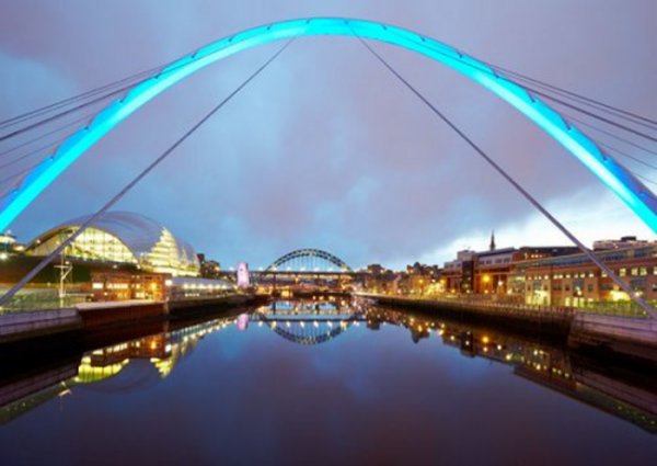
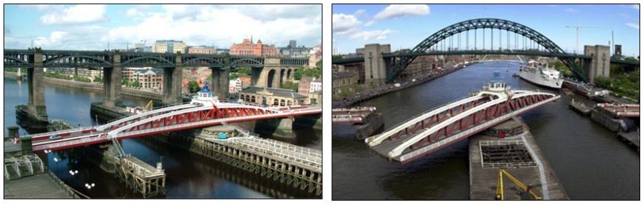
THE SWING BRIDGE
The River Tyne became more and more active as the gateway to so many varied industries. Ships of all sizes required access to either off load raw materials, or to pick up finished products including coal. It was recognised that the existing stone arched bridge which was built in 1773 was outdated. Large ships, especially ships with tall masts were denied access to the Tyne. The arches of the current bridge were far too low.
One of the key industries at that time was the armaments factory at Scotswood owned by Lord W.G.Armstrong, he in particular had a vested interest in creating access for larger vessels to pick up huge weaponry and the like. He designed and financed a new hydraulic swing bridge, it would provide for the needs of all transport, by land as well as by river. Although its original concept was Armstrongs it was the Tyne improvement Commission who actually built it, with Armstrong & Co as contractors
The old stone bridge was removed and the Swing Bridge was built on the site between the years 1866 to 1876. It was 560ft.long and 47ft.wide. The weight of the swinging portion of the bridge is about 1,500 tons, the length 281ft. About 900 tons of this weight floats on a centre water press 62 inches in diameter with a hydraulic pressure on this press of 700lbs. per square inch. The machinery for turning the bridge is on the centre pier and is in duplicate, it turns ninety degrees clockwise to open and of course ninety degrees anti-clockwise to close. The bridge is turned by hydraulics engine working at 700lbs. per square inch. The hydraulic power was generated by steam power and used about one ton of coal per week, it was eventually converted to operate on electricity. The cost of the bridge was £240,000.
It was the first hydraulic bridge of its kind anywhere in the world and opened up to all shipping the upper reaches of the Tyne. Extensive dredging made it possible to form a harbour at nearby Dunston, from there millions of tons of coal were shipped annually. Although at this moment in time, the Tyne is no longer so busy with shipping, the Swing Bridge is still carrying out a necessary function. Its main use is for road and pedestrian traffic, although there are still many occasions when it needs to open for river traffic. To date 1995, the Bridge has been scheduled as an ancient monument.
|
|
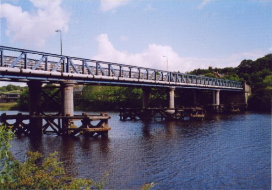
NEWBURN BRIDGE
Newburn Bridge is a road bridge crossing the River Tyne at Newburn in Newcastle upon Tyne, England. It links Newburn, Walbottle and Throckley on the north side of the river with Ryton, Stella and Blaydon on the south side.
The bridge is the western most crossing of the Tyne in the county of Tyne and Wear; the next crossing upstream, Wylam Bridge, is in Northumberland.
This part of the river has been forded since Roman times because it is the most eastern part of the Tyne that is easily fordable. There have also been numerous ferries operated in the part of the river around Newburn. A bridge was finally built between 1892 and 1893. It was designed by Sandeman & Moncrieff of Newcastle and built by Head Wrightson of Thornaby-on-Tees.
It was opened on 21 May 1893. For the first 50 or so years of its use it was a toll bridge, until it was bought by Northumberland in 1947. The toll house on the north east side of the bridge has since been demolished. The bridge used to have two lanes crossing it up until the 1960s. It has since had single road traffic because of the weight limit of 9 tonnes (8.858 long tons; 9.921 short tons), later raised to 10 tonnes (9.842 long tons; 11.02 short tons).
In 2007 the bridge was closed for a number of months for renovation and repainting.
|
|
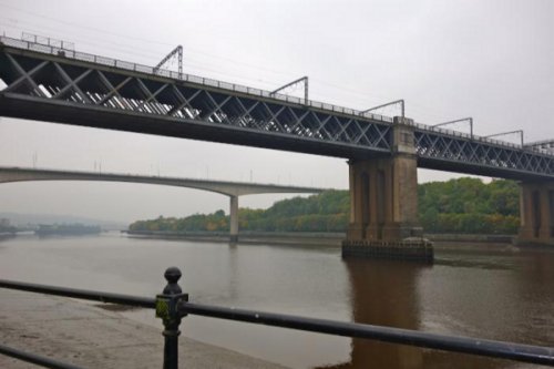
The King Edward Bridge
Known to generations of railwaymen as the KEB the King Edward VII Bridge was needed at a time when rail traffic over the High Level bridge was increasing and the inconvenience of trains having to reverse out of the Central Station to continue their journey north could no longer be tolerated. The bridge was built for the North Eastern Railway Company (NER), designed by Charles A. Harrsion of the NER, and constructed by the Cleveland Bridge and Engineering Company. Work commenced in 1902 and the bridge was opened by King Edward VII on 10 July 1906 but not brought into regular use until October 1st. The usual method of testing with several locomotives crossing the bridge was used.
Problems with foundations meant that plans for a girder span at the Gateshead side were changed and stone arches used instead. Caissons support the three granite river piers and massive steel lattice girders carry the four railway tracks. The viaducts on the south side are of red sandstone. The new bridge, together with the High Level completed a loop of railway tracks using both sides of the Tyne making train movements easier. Trains from north or south of Newcastle could now enter or leave via the new bridge and the west end of Central Station, which now became a through station for north-south trains. At the Gateshead end are two viaducts, one turning west and one east so that trains can be sent in either direction. The four tracks ar now just three and the track layout has been simplified following the closure of the locomotive shed at Greenesfield and perhaps also as a consequence of the reduction in the number of freight trains using the bridge.
The King Edward bridge is arguably the most solid-looking bridge on the Tyne as can be seen by standing on the river bank in Gateshead and looking up. The bridge was wired for the electric train services now using the East Coast Main Line. It is Grade Two listed.
|
|
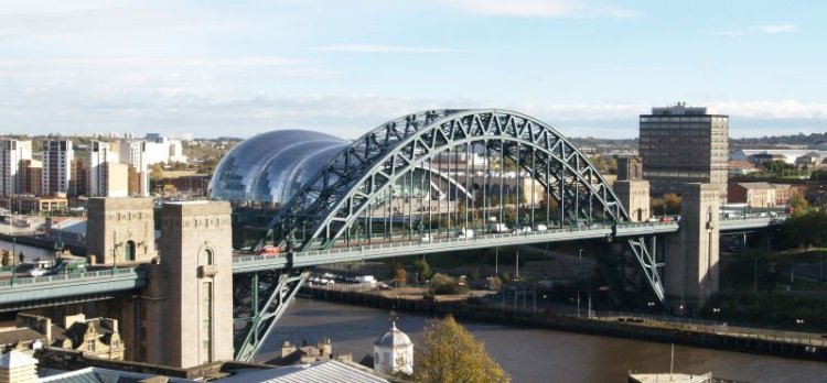
The Tyne Bridge
The idea for a bridge at the location of the present Tyne Bridge dates to 1864, due to concern about the cost of tolls on the High Level Bridge. The first serious discussions took place in 1883. Committees met over the next three decades, but it was not until the early 1920s that proposals were commenced in earnest, boosted by the chance to secure central government funding. On 29 April 1924, Newcastle and Gateshead approved the plans, and the Newcastle upon Tyne and Gateshead (Corporations) Bridge Act was passed on 7 August that year, with an estimated cost of £1 million including land acquisitions. The final cost on completion was £1.2 million.
Work started in August 1925 with Dorman Long acting as the building contractors. Despite the dangers of the building work, only one worker, Nathaniel Collins, a father of four and a local scaffolder from South Shields, died in the building of this structure.
The Tyne Bridge was designed by Mott, Hay and Anderson, comparably to their Sydney Harbour Bridge version; based on the design of the Hell Gate Bridge in New York City (which was completed in 1916). The bridge was completed on 25 February 1928, and officially opened on 10 October by King George V and Queen Mary, who were the first to use the roadway, travelling in their Ascot landau. The opening ceremony was attended by 20,000 schoolchildren who had been given the day off. Movietone news recorded the speech given by the King.
The Tyne Bridge's towers were built of Cornish granite and were designed by local architect Robert Burns Dick as warehouses with five storeys. But, the inner floors of the warehouses in the bridge's towers were not completed and, as a result, the storage areas were never used. Lifts for passengers and goods were built in the towers to provide access to the Quayside; they are no longer in use.
The bridge was originally painted green with special paint made by J. Dampney Co. of Gateshead. The same colours were used to paint the bridge in 2000. The bridge spans 531 feet (162 m) and the road deck is 84 feet (26 m) above the river level.
Tram lines were built into the Tyne Bridge structure and ready for immediate use after the opening ceremony in October 1928. Tram car No. 289 was the last Newcastle tram to run into Gateshead over the Tyne Bridge on Sunday 5 March 1950 at approximately 10.55 pm. The tram lines were subsequently removed, although some vestiges of these remain such as redundant fixings for overhead power lines.
Golden jubilee celebrations were held on 10 October 1978, when 1,000 balloons were released into the sky above the river to celebrate the anniversary of the Tyne Bridge. To mark the occasion, a cavalcade of vintage vehicles and a procession of people in period dress stopped traffic, re-creating the opening ceremony when King George V declared the bridge open in 1928.
Upon opening, the bridge carried the A1 road. Following the opening of the Tyne Tunnel in 1967, however, the A1 was diverted to the East and the road became the A6127. Following the construction of the Newcastle Western Bypass, the A1 moved again. The bridge was redesignated as the A167, which it remains today.
In 2012, the largest Olympic rings in the UK were erected on the bridge. The rings were manufactured by commercial signage specialists Signmaster ED Ltd of Kelso. The rings were over 25 metres wide and 12 metres tall and weighed in excess of 4000 kg. This was in preparation for Newcastle hosting the Olympic football tournament, and the Olympic torch relay, in which Bear Grylls zipwired from the top of the arch, to Gateshead quayside.
On 28 June 2012, a large lightning bolt struck the Tyne Bridge. It lit up the roads as the sky was very dark. The bolt, part of a super-cell thunderstorm, came with heavy rain a month's worth of rainfall in just 2 hours - causing flash flooding on Tyneside.
|
|
THE QUEEN ELIZABETH METRO BRIDGE
The Queen Elizabeth II Bridge carries the Tyne and Wear Metro between Newcastle upon Tyne and Gateshead over the River Tyne in northeast England. The line is in tunnel on either side of the river and only emerges into open air to cross the bridge. The bridge was developed as part of the Tyne and Wear Metro system, for which it was purpose-built. It was designed by W. A. Fairhurst & Partners, and constructed by Cementation Construction Ltd. and the Cleveland Bridge & Engineering Company at a cost of £4.9 million. The two sections of the bridge were built simultaneously from each bank and eventually met in the centre. It was officially opened by Queen Elizabeth II on 6 November 1981, nine days before regular Metro service began.
In 2006, Nexus, operators of the Metro, commissioned artist Nayan Kulkarni to install a huge artwork on the bridge. The artwork, Nocturne, sees the bridge painted two distinct tones of blue, while at night, 140 Lumiflood LED lighting units create an ever-changing pattern of colours based on photographs submitted by members of the public.
Nocturne was completed and opened on 26 April 2007 and means that all five main bridges across the Tyne between Gateshead and Newcastle have unique lighting schemes.
|
|
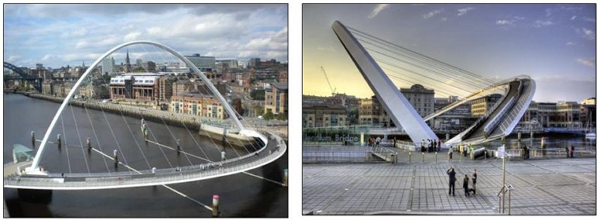
THE GATESHEAD MILLENIUM BRIDGE
Few structures can stand as a monument to mans ability, to his understanding of the river and to his vision, as well as the Gateshead Millennium Bridge.
At the cost of £22 million and with a revolutionary design that enables it to convey pedestrians and cycles, yet to ‘flip over’ to allow ships to pass up the river, it became the focus of world-wide attention from the moment of its conception. Its image appeared on stamps, every scrap of information about it was eagerly digested by those who live here, those who left and those who’ve never even been, but who wanted to follow the progress of the latest of the Tyne’s famous bridges.
Several times its procession up river and into position was postponed due to the bad weather. Water levels, currents and an increase in the wind speed above 25mph made all the difference and speculation abounded as to whether the steel construction, which weighs more than 850 tonnes, has a span of 413ft (126m), and rises 164ft (50m) above river level, would ever reach its resting place. Then, on Monday, November, 20, engineers decided conditions were perfect for the bridge to make the six-mile journey from the Amec yard in Wallsend to the Gateshead Quays. Crowds lined the river on both sides to watch as the Asian Hercules II crane, which had a deck the size of a football pitch and lifting legs which projected more than 350ft into the air inched its way up river.
In a manoeuvre in which a millimeter was as significant as a mile, they held their breath to see if the Millennium Bridge would span the Tyne in the manner of so many before it. To see it slide smoothly into place was to watch history in the making. It is 100 years since the last opening bridge was placed across the Tyne and we are unlikely to see such a sight again in our lifetimes. The Bridge was opened to the public in 2001.
In years to come we who were there, who read about it or saw it, will tell our children and their children about the day the ‘‘blinking eye” bridge, with the world’s first tilting mechanism, threw its graceful arc over the river from which we Tynesiders take our name. And long after we are gone it will, God willing, stand at the entrance to our river.
In years to come the Gateshead Millenium Bridge will become as famous a landmark as the Tyne Bridge. Already, in fact, just days after the 850-plus-tonne structure was moved into place on the Tyne, it is being talked about globally. When it is launched next summer it will be the first bridge in the world to open the way it does - pivoting upwards, like an eyelid blinking. The pedestrian and cycleway construction has cost a staggering £22million and contains enough steel to make 64 double-decker buses or 16 Chieftain tanks. And the overriding opinion of locals is that it is money well spent. But what you see isn’t necessarily all you get.
Try visualising this: it sits on 19,000 tonnes of concrete - that is the equivalent of 600,000 paving stones (180 miles) and there are also 650 tonnes of steel reinforcement.
Rising 50 metres above the water, its foundations go 30 metres under the Tyne. But there’s so much more to it than even that. In April last year local transport minister Glenda Jackson issued an order under the Transport and Works Act granting Gateshead Council the powers to build the bridge. Harbour and General was given the contract after a rigorous selection process, taking into account technical capabilities and the ability to work co-operatively.
Gateshead Council was keen on a partnering approach to project manage the scheme and, therefore a representative from each group - client, engineer, architect and contractor would meet regularly on a monthly basis to keep progress smooth. Over the past year and half, the project has involved dredging a section of the Tyne, building two reinforced concrete abutments in a tidal river and the fabrication and installation of the fully operational bridge. So, when it does eventually open, how will it be done? Well, a couple of concrete piers on each side of the river hide the pivots, hydraulics and motors, which operate the structure. Huge hydraulic rams will open the bridge, powered by eight electric motors totalling 440 kilowatts - using enough power to light 2,200 100-watt light bulbs. Bad for the environment? Not when you consider it is so energy efficient it will actually only cost just £3.60 for each opening - the whole process taking just four minutes. And its stature will change depending on the time of day - in daylight it’s a pale chalk blue, but in darkness, its reflection lights the Tyne. It is also instrumental in the regeneration of Newcastle and Gateshead Quaysides.
|
|
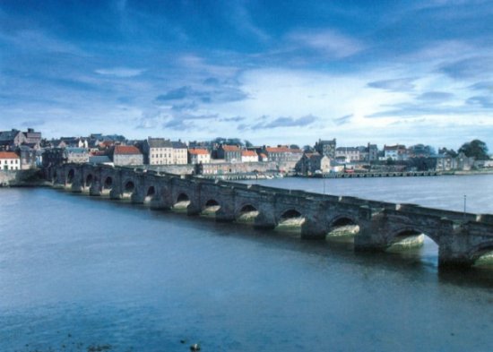
Berwick on Tweed
An ancient Border town, the most northerly in England, whose three bridges astride the River Tweed, Berwick is one of the best examples of a fortified town in Northern Europe. Its long and chequered history, from 547 A.D., is characterised by bitter conflicts and feuds fought backwards and forwards across its land. A Scottish Royal Burgh in the 12th century, it was finally established as part of England in 1482.
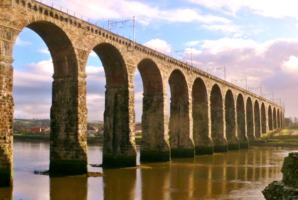
Little remains of the 12th century castle which was plundered for its stone, most notably by Robert Stephenson to build the famous Royal Border Bridge of 28 arches which was opened by Queen Victoria in 1850. The site of the castle was finally cleared to build the present Railway Station during the 19th century.
Pictured is the middle of the three bridges, the Royal Tweed Bridge, designed to carry the Great North Road between England and Scotland. The oldest surviving bridge, completed in 1634, has one parapet higher than the rest, which originally served to mark the boundary between Berwick and North Durham. Sailing serenely beneath the
bridges, Berwick's famous mute swans present a wonderfully tranquil sight.
Excellently maintained are the Elizabethan fortifications which encircle the town, unique in their size and remarkable state of preservation. The ramparts are open to the public and from them can be viewed a rich variety of historic buildings including the Guildhall, Holy Trinity Church and the Georgian Custom House in the Quay Walls.
The Town Hall, with its impressive 150 feet steeple, contains the Cell Block Museum. As a one¬time garrison town, Berwick boasts the first Barracks built in this country, which now houses the King's Own Scottish Borderers Regimental Museum, Berwick Borough Museum and Art Gallery, including the Burrell Collection of art treasures.
With an international reputation for its salmon industry, Berwick is a bustling market town with good shopping facilities and provides an excellent start for excursions around the Border Country. During the ceremony of 'Riding the Bounds' in May, horsemen follow Berwick's ten mile boundary accompanied by the mayor and civic party.
|
|
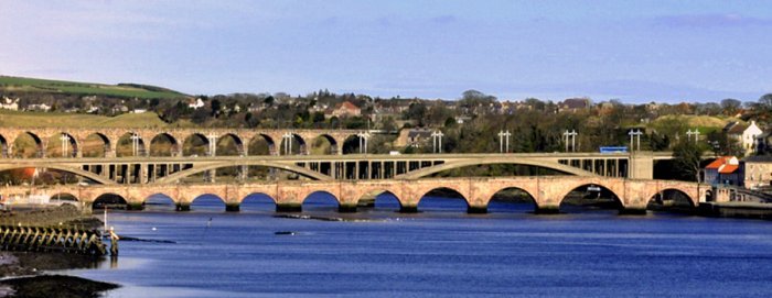
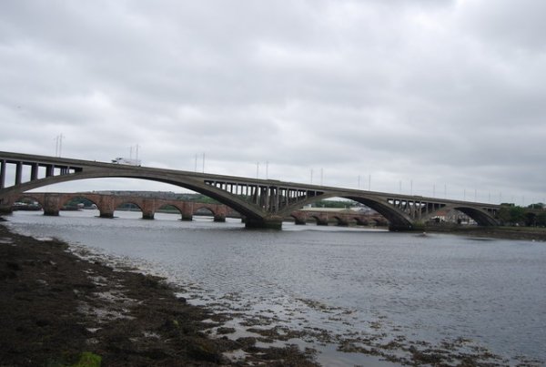
The Three Bridges
Pictured in the foreground is the Berwick Bridge or Old Bridge as it is known locally. It was built between 1611 and 1634, and until 1928 it was the main road bridge over the River Tweed. Its designer was James Burrell engineer, who was the Surveyor of Works of the fortifications in Berwick and overseer of the project. He was assisted on the project by lead mason Lancelot Bramston and lead carpenter Roger Richardson along with a large contingent of other masons, carpenters, labourers and quarrymen. The Berwick Bridge is 354.8 metres long with 15 segmental arches; it is 14 metres high at its highest point near the Berwick side, and 5 metres wide. The largest arch, the penultimate on the Berwick side, is 22.9 metres, the deck falling gradually towards the Tweedmouth side. The red sandstone required for the building of the bridge was quarried locally. The piers were founded on wood piles; the 800 plus oak trees which were required for piling came from the Chopwell Forest near Newcastle and were shipped to Berwick. Although work on the bridge was more or less complete in 1624 it was not until 1634 that the accounts were finally closed and the bridge was officially completed. The Berwick Bridge was the largest bridge constructed in the country during the 17th century. The accounts for the Berwick Bridge from 1611 are held at the Berwick Record Office.
In the centre is the Royal Tweed Bridge, which was constructed by L G Mouchel and Partners between 1925 and 1928; it was opened in 1928 by the Prince of Wales, later King Edward VIII. In the early part of the 20th century, the bridge was notable for its size, and for the way that its four arches increased in size from the south to the north, taking into account an upward gradient. The arches measure 50.9 metres, 75.6 metres, 86.9 metres and the fourth at 110 metres was the longest arch in Britain when the bridge was built. The Royal Tweed Bridge carried all the main A1 road traffic through Berwick until the opening of the Berwick bypass to the west of the town in 1983.
In the background is the Royal Border Bridge; it was the last remaining link in the east coast rail line from London to Edinburgh, and it was opened in August 1850 by Queen Victoria. The Royal Border Bridge was commissioned as part of the Newcastle & Berwick Railway line. Robert Stephenson, its architect, was the railway’s engineer, though most of the line engineering was undertaken by Thomas Harrison under Stephenson’s supervision. The viaduct is built on a curve and consists of 28 arches; the bridge was constructed in masonry with brickwork soffits (under-sides of the arches) covered by stone cladding. The arches each measure 18.6 metres and the whole bridge is 658 metres long; with the greatest height over the bed of the river being 38.4 metres. The bridge contract covered a one mile length of line, and the non-masonry sections consist of earth embankments at the Tweedmouth end of the bridge.
|
|
The Royal Tweed Middle Bridge was intended to divert traffic from the 17th century Berwick Bridge, and until the 1980s it formed part of the A1 road, the main route from London to Edinburgh. However, the construction of the A1 River Tweed Bridge to the west of Berwick has since reduced the Royal Tweed Bridge's importance.
|
|
The Border Rail Bridge
The speed of rail travel made it possible for the first time to move perishable goods great distances overnight, ensuring that cities were adequately supplied. London’s population of about 1.5 million in the 1830s was considered barely sustainable, but thanks to the ready supply of food to the capital, it had risen to more than 6.5 million by 1900.
|
|
|
|
|
|