|
|
Inside & Around The Ancient Town of Corbridge
|
CORBRIDGE
Corbridge, which is now a quiet
village, once ranked as an important
Northumbrian town. In Roman times it
was one of the largest stations in the
north of England, called in the
Antonine Itinerary Corstopitum. But
before that the Britons probably
occupied the site since many of their
camps and burial mounds are to be
found in the neighbourhood; remains
which go back to the early Bronze Age.
The Roman station occupies a gentle
rising near the Cor burn, 600 yards
west of the town and was approached
from the south by a bridge whose
foundations can be seen when the river
is low. This bridge carried across the
Tyne one of the great Roman military
roads - the famous Watling Street.
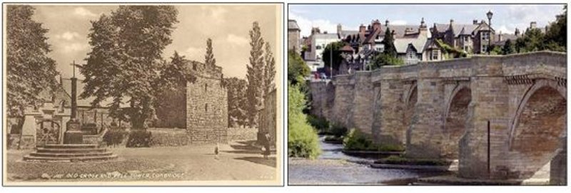
The bridge at Corbridge was built in
1235. In 1674 it was replaced by the
seven-arched bridge we see today.
During the great Tyne flood of 1771 it
was the only bridge on the river that
was not destroyed. In 1881 it was
widened by three feet but its
appearance was not spoilt.
ANGLIAN CORBRIDGE
Although some English towns sprang up
on the sites occupied by the Romans
the new settlements were usually in
the immediate neighbourhood, possibly
from superstitious motives. The parson
at Corbridge informed Leland in the
reign of Henry VIII:
By this broke (the Cor-burn) as emong
the ruines of the olde town is a place
caullid Colecester, wher hath beene a
forteres or castelle. The peple there
say that ther dwellid yn it one Yoton,
whom they fable to have beene a
gygant. This legend of a giant called
Yoton lasted for many centuries.
In 1660 we read:
Near Corbridge, not far from
Northumberland, the late rains having
wash'd away the earth in a place where
a torrent was made by the winter
rains, there was discovered the
skeleton of a prodigious monster, the
skull capable of holding three
gallons; the hollow of the back-bone
was so large that a boy of eleven
years old thrust his hand up it to the
elbow; the thigh bone is two yards
long, lacking two inches; his whole
height computed to just twelve foot or
seven yards. The skeleton being found
by boys, they broke it in many pieces,
which my Lord Darwentwater, who hath a
great part of it whole, would have
given some hundreds of pounds if he
had it entire. The skull hath twenty-
four teeth in it. I myself have seen
one of them in Newcastle, which is
one inch and six tenths of an inch
broad and three inches deep, and is
now four ounces, al¬though dryed.
There is also another tooth of the
same to be seen at Widow Ingram's
coffee house in Prescot Street in
Goodman's fields.
The first written evidence of
Corbridge's existence occurs in 800
A.D. when the Anglican settlement is
called Et Corabrige. The name is
clearly derived from the Roman bridge,
and is therefore one of the few places
before the Norman Conquest named after
a bridge. However it is not known
where the first part of the word -
COR - comes from. The Cor burn clearly
derives its name from the village.
Probably the word COR is that part of
the Roman name which survived.
We are told that in 786 a bishop was
consecrated at the monastery of
Corbridge.This monastery is clearly
the parish church whose porch was
built entirely of Roman stones. The
style of the building is similar to
the seventh century churches of Jarrow
and Monkwearmouth. It is dedicated to
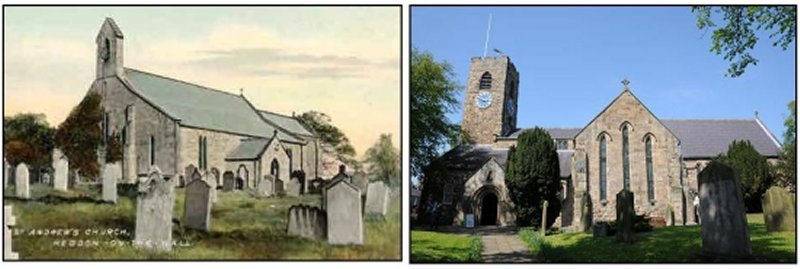
St. Andrew like four other Tyne valley
churches, Bywell, Hexham, Heddon and
Newcastle.
It has been suggested that when the
kingdom of Northumbria declined and
Bamburgh was no longer used as a
capital the royal seat was removed to
Corbridge. The town certainly
pros¬pered mainly because it was at
the junction of two ancient high¬ways,
namely Dere Street (Watling Street)
and the Stanegate. The Roman Stanegate
(later called the Carelgate) or "ald-
he-way" was the main road across the
isthmus from Tynemouth to Carlisle,
until General Wade built his military
road.
This trade led to the early
establishment of a market which is
first men¬tioned in the 13th century
but clearly had been in existence long
before. There was also an annual fair
in existence in 1293, which was
probably held at Stagshaw Bank a mile
to the north on Dere Street. This fair
survived into the 20th century with
the development of the lead and silver
mines at Alston. Corbridge appears to
have had a royal mint. Coins have
survived of Henry I with the name of
the moneyer on them EREBALD ON COLEB,
the last word being Corbridge. At this
time the royal tax of tallage paid by
Corbridge was' as high as Newcastle
showing the relative importance of the
two places. In 1201, when King John
was in the north, he caused a search
to be made at Corbridge imagining that
the town had once been large and
populous, and must have been ruined by
an earthquake, or some sudden and
terrible invasion, and that in either
case the people would have been unable
to remove their wealth. Tradition says
the search was in vain.
|
|
MEDIEVAL CORBRIDGE
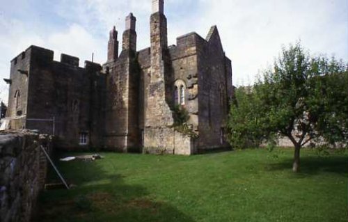
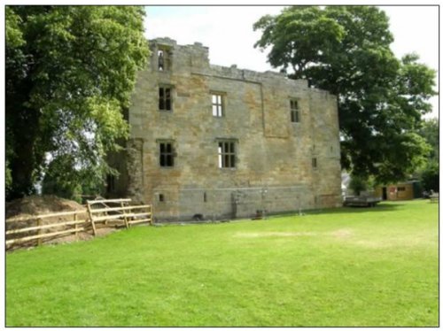
The town was at the height of its prosperity by the end of the thirteenth century. (Pictured above Aydon Castle built in the thirteenth century). In 1296 we have the first detailed account of taxation in Corbridge. This was a royal tax on moveables called the Subsidy Roll and a total of seventy-seven people were taxed which made this the largest town in the county after Newcastle, where 297 people paid subsidy. Alnwick had forty nine names and Morpeth thirty-five. It has been estimated that one person in twenty paid tax, so the population of Corbridge would be 1,500, Newcastle 6,000, Alnwick 1,000, and Morpeth 700.
The names of weaver, miller, dyer, tailor, goldsmith, forester, butcher and slater attached to various inhabitants illustrate the trades carried on at that period. In 1295 Corbridge sent two representatives to the model parliament of Edward I. Their members were Adam son of Alan and Hugh son of Hugh. Bamburgh and Newcastle also sent members, but on later occasions only Newcastle was represented.
In 1296, 1312 and 1346 the town was burnt by the Scots but 1349 was even more disastrous; it was then that the Black Death over ran England. Tradition says that the only inhabitants to survive were a few who camped in an open field called the Leazes, which was north of the town in a higher and healthier situation.
Writing in 1830 Hodgson thus describes the town:-
The town (for such its antiquity demands that it be styled) is dirty, and in all the streets except that through which the Newcastle and Carlisle road passes, is filthy with middens and pigsties, with railing before them of split board, etc. The population seem half-fed; the women sallow, thin armed, and the men flabby, pot-bellied, and tender-footed; but still the place bears the appearance of being ancient. To such an extent had the town declined from its ancient estate. Seventy years later Tomlinson describes Corbridge "as one of the most picturesque and interesting of Northumbrian villages, as it is one of the most considerable.
From its high and dry situation on a gravelly hill, which is sheltered on the north and south by the steep sides of the river gorge, combined with the loveliness of the surrounding country, Corbridge has become one of the most popular health resorts in the country. Few villages, indeed, have so many natural advantages, and these are supplemented by historic associations of exceptional interest".
|
|
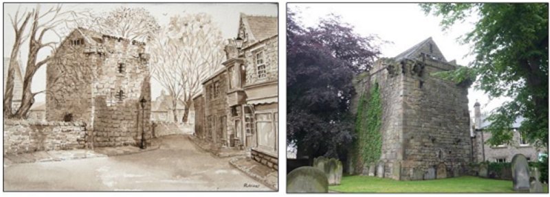
THE VICARS PELE
There are many peles in Northumberland
which have been (and still are) used
as vicarages but this is the only one
actually standing within the
churchyard.
Although there is no record of its
erection the architectural features
suggest a time about 1300. It is first
mentioned in the list of fortalices
drawn up in 1415, wherein it is
described as belonging to the vicar. A
survey of 1663 describes it as 'a
tower situated on ye churchyard wall,
to ye south-east of ye church, said to
have been antiently ye lord's goale,
but now is ye place where ye lord's
court is usually kept, but ye roofe,
is in much decay".
The tower, is of one date and well
built of Roman-worked stones brought
from Corstopitum. It is a good example
of the smaller pele and show domestic
arrangements rarely seen in such
perfection. It is three storeys high
and has an embattled parapet carried
round the corners on projecting
corbels forming machicolations.
The entrance is at ground level by a
heavy door of old oak planks covered
with an iron grate similar to that at
Bywell Castle, leading to a vaulted
basement where the vicar stabled his
horse and stored his provisions. A
stair mounts in the thickness of the
wall to the first floor which was used
as a living room. On the first floor
landing is a stone table with a wash
basin.
The first floor is entered by a
pointed doorway and is lighted by
three windows. It has two wall
cupboards, a large fireplace and
window seats. The floor above, of the
study bedroom, is gone. Near a small
window in the north wall is a recess
clearly intended as a book rest. While
reading the window commanded a view of
the church and its approaches. It is
easy to picture life in this medieval
tower.
|
|
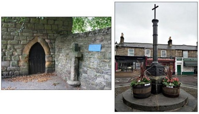
MARKET CROSS
In the middle of the market place used
to stand a market cross, pictured
above left. It was emplanted on a
large Roman altar. The cross stood
until 1807 and was replaced in 1814 by
a cast-iron structure, pictured above
right.
From the cross the proclamation of
Stagshaw Bank Fair used to be made.
The cross now stands in front of the
Roman Catholic Cathedral in Newcastle.
|
|
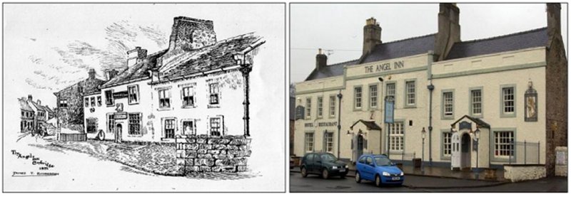
INNS AND TAVERNS
The Angel Inn, formerly called
the "Head Inn", is the oldest inn in
the village. It is said that the
king's commisioners stayed there, when
on their mission to suppress the
monastery at Hexham.
From 1752 until the opening of the
railway the" Angel" was the posting
inn for Corbridge; once a week the
mail coach halted at the inn and the
landlord read to the local people who
had assembled at the Coen's foot the
news from the Newcastle papers.
The central portion of the inn is the
oldest. The semi-arched doorway and
the mullioned Tudor window on the
right of it belong to the original
structure. The wings on either side
have been considerably altered and
rebuilt. In the west gable are two
small and original circular openings.
Above the door is a fine old sun-dial
bearing the inscription E. W. A. 1726,
for Edward Winship and his wife Anne.
There is also a stone carved with the
arms of Newcastle accompanied by a
couple of masonic symbols. This is the
emblem of the Incorporated Company of
Masons of Newcastle. Why it has been
put there is a mystery. In the
nineteenth century stood a stone dog
on the gable. This has been removed
for safe keeping and now stands on the
lounge mantelpiece. It is thought to
be of Roman workmanship.
In the interior are several ancient
features, the timbered ceiling the
balustrade of the staircase, and
remains of a large fireplace with
a "spit". The stonework at the rear is
of early date and the old stables
still have their original dividing
stalls. The "Angel", like other inns
of the same name probably derived its
sign from a religious picture of the
Annunciation. As parts of the picture
faded only the angel remained visible
to passers-by.
The Boots and Shoes Inn, another old
posting inn, used to stand in Water
Road. It has now disappeared. At one
time shoemaking was the principal
trade of Corbridge. Large quantities
of shoes were made for lead and coal
miners and Shields fishermen. The inn
clearly derived its name from this
local industry. At the east end of
Main Street is a house called Monks
Holme. It was formerly the "New Inn".
Although its thatched roof has gone
the Wheatsheaf, another old hostelry,
still remains. In the stable yard can
be seen two curious stones, probably
of Roman workmanship. The chief of
these is a stone figure thought to
represent the goddess Ceres. In one
building there is a corner stone
showing two heads facing in opposite
directions.
The Golden Lion Inn, in Hill Street,
was built with stones taken from
Dilston Hall when it was demolished in
1768. The part of Dilston Hall taken
down had been erected in 1618 by Sir
Francis Radcliffe.
|
|
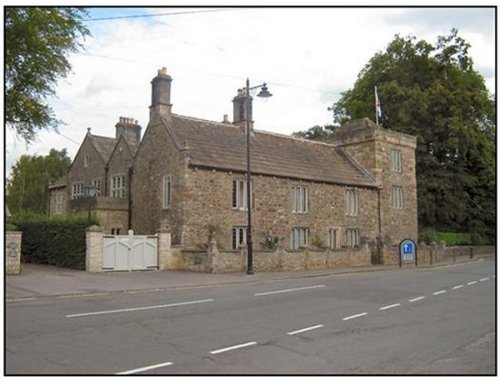
LOW HALL
Apart from the Vicar's Pele the oldest
remaining house in Corbridge is the
Low Hall at the east end of Main
Street where the Newcastle road
passes into the village.
The nucleus of the building is a
medieval pele tower three storeys
high. It retains many of its original
features including the vaulted roof of
the basement. In entering the tower
from the adjoining house by the
original entrance there is first a
small lobby from which a straight
stair goes up in the thickness of the
wall giving access to the upper
floors, and a door head admits to a
vaulted basement. It is lit by a small
loophole in the north wall, and the
window looking on to the road probably
the position of another loophole.
The tower itself was built by the
Baxters, probably in the late
fifteenth century and for long was
known as Baxter's Tower. The Baxters
were a prominent Corbridge family at
that time. One of them, called
Alexander Baxter, was setter and
searcher of the watch at Corbridge in
1552. The Baxter property came into
the hands of Richard Gibson of Hexham
in 1675. He was probably the builder
of the Low Hall attached to the
Baxter's tower. Over the entrance is a
sun-dial dated 1700. The hall was
lighted by mullioned windows and at
the same time windows of a like
character were inserted in the tower,
and a gabled projection was built onto
the rear. Later all the mullioned
windows were replaced with smaller
ones. The window tax of the period was
probably responsible for this
reduction in window size.
George Gibson, grandson of Richard
Gibson took part in the Jacobite
rebellion of 1715 and was attainted of
high treason and died in the Fleet
prison the following year. Most of his
property, including the Low Hall, was
forfeited to the Crown. It was bought
for £360 by John Aynsley, a Hexham
attorney.
|
|
St ANDREWS PARISH CHURCH
Even the oldest 'born and bred'
Corbridgean can recollect but a small
part of the village's history. Apart
from the several church guides, more
detailed notes can be found in 'The
History of Northumberland’ or if you
are after more social and economic
details you should acquire a copy of
Corbridge Border Village by Walter R.
Iley, who was for several years one of
the guides in St. Andrew's. Walter had
the wonderful knack of bringing
history to life. It is quite certain
that although the Romans had a store
camp at Corstopitum during the time of
their occupation, most of village life
seems to have evolved around St.
Andrew's Church. St. Wilfred,
responsible for the building of Hexham
Abbey, sent his monks to Corbridge
among other places to build a Saxon
Church or a monastery. There are still
remains of that church built about
774. The monks, we would say, went out
and about to minister to the spiritual
needs of the community.
The Church we see in the centre of
Corbridge has been radically altered
and modernised to deal with Danish and
other marauders through the centuries.
Reminders of this can be seen inside
and outside - inside four arches cast
our minds back, the Saxon window at
the west end of the church, the Roman
archway at the base of the tower, the
Norman doorway and, one of the gems of
St. Andrew's, the beautiful early
English archway.
Outside there is the fortified pele
tower used by earlier vicars as a
vicarage. Back inside there is much
evidence of other points in the
history of St. Andrew's. The grave
slab of Aslin, son of Hugo, a reminder
that Corbridge at one time sent
members to Parliament. St. Andrew's
carried out many alterations in the
nineteenth century - some of which are
arguably good and some bad. Changes in
our social life are taking place all
the time as in our liturgy. The next
year or so will see more changes in
St. Andrew's to make it more suited
for the 21st century.
Perhaps we should remember that
St.Wilfred sent his monks to
Corbridge to minister to the needs of
the local inhabitants - and we in the
21st century, as regular worshippers,
have the same task not only to worship
but to go out into our lovely village
and minister to our other villagers.
Activities based at St. Andrew's
include regular worship, a young
people's church, a mothers' union, a
women's fellowship, prayer groups and
a choir.
|
|
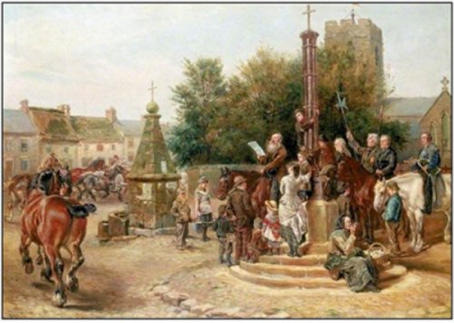
STAGSHAW BANK FAIR
One of the most famous north country
fairs used to be held annually on 4th
July at Stagshaw Bank near Corbridge.
Before the days of railways it was a
large cattle and sheep fair and at
times 100,000 of the latter were on
sale. Many of the sheep were brought
by Highland drovers from Scotland. The
fair was a great festival for the
district. Rev. James Raine thus
describes the scene.
Upon reaching Stagshaw Bank, a large
tract of open ground, not far from
Corbridge, inclining swiftly from the
Roman Wall to the Tyne, we found
ourselves in the midst of a great
annual fair held on this declivity,
chiefly for cattle, but in truth for
goods of all kinds, 'things', as an
old inventory at Durham has
it, 'moveable or moving themselves'.
At this place, which is a solitary
field, at a distance from any
population, there are great well known
periodical gatherings of buyers and
sellers from the whole north of Eng
{and, on the western or eastern coast;
and the southern counties of Scotland
send forth in abundance their men and
goods to buy, sell, or be sold.
In a large pasture upon the slope of a
hill, with a wide prospect, extending
down the valley of the Tyne as far as
Gateshead Fell, and in every other
direction except the north, having an
almost unlimited view of a spreading
tract of country, there were gathered
together, without the slightest
attempt at the order which is of
necessity observed in markets and
fairs held within the walls of a town,
horses and cattle, and sheep and
swine, and in short everything which
is bred or of use in farming
operations, with thousands of other
things, which it would be no easy task
to enumerate; and then there were
people of all ages, from all quarters,
and in all kinds of costume; the
Scotchman in his kilt, and the
Yorkshireman in his smock-frock; and
every variety of booth or hut for
refreshment or dissipation.
That we had stumbled on a fair of
Roman origin may not, I think, be
doubted. The situation of Stagshaw
Bank is an extremely convenient one
for gathering together at stated
periods of the year the produce of
this the eastern side of the island;
and as long as the Romans were in
possession of Britain, and there was
an immense population along the line
of the Wall from sea to sea, the
natives would find a ready market for
the produce of their fields and
farmyards.
The Wall, which runs at the distance
of a mile northwards, would be a
protection to the sellers of cattle
and wares in that direction; and from
the south they had nothing to fear.
Pictured above a painting by Ralph
Hedley, shows the fair being
proclaimed in the market place of
Corbridge by the bailiff of the Duke
of Northumberland.
|
|
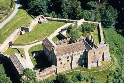
AYDON CASTLE
Aydon Castle, a private residence for
almost seven hundred years has now
been taken over by the Ministry of
Public Building and Works. It is an
almost perfect example of a fortified
manor house built at the end of the
thirteenth 'century. It stands midway
between the large Northumbrian
castles . like Alnwick and the small
towers or peles of which two can be
seen in Corbridge. It can.be reached
by road from Aydon or by foot from
Corbridge.
The original house was probably
commenced by Robert de Raymes in 1296,
and license to embattle and fortify
was granted in 1305. Later owners were
the Carnabys, the Carrs, the
Collinsons, and the Blacketts of
Matfen.
The first buildings comprised the
house and the inner bailey. Later
(probably in the fourteenth century)
the courtyard and outer bailey were
added. The entire defences are still
astonishingly complete. The original
main building is cruciform in plan,
well built, and two storeys in height.
The hall and chief rooms were on the
second floor and were entered by an
external staircase in the courtyard.
The main hall is lighted at the east
end by two windows each of two pointed
lights separated by a decorated shaft
and enclosed within a pointed arch.
There is no fireplace.
Divided from the hall by a narrow
passage or screens is the kitchen with
fireplace, locker, kitchen sink and
two fine original windows. The
fireplace was added by the Carnaby
family in the sixteenth century and on
it is rudely carved their coat of
arms. At the opposite end of the Great
Hall was the solar.
The room below the Great Hall has a
fireplace whose jambs are moulded
shafts of fine workmanship. But the
most striking feature is the chimney
which constitutes the most singular
feature of the south front of the
castle. For about half its height it
has the ordinary buttress-like
appearance of a projecting chimney.
Half way up it becomes semi-circular
and terminates at the parapet in a
conical cap. Beneath the cap are two
slits for the escape of the smoke. In
the basement of the west wing are the
stables. The roof is of stone and
vaulted, and the mangers are also
constructed of stone. A battlement
parapet runs round the whole of the
house, except the west wing. The water
is carried from the gutters by a
series of projecting stone spouts or
gargoyles.
A rock on the edge of the dene, which
the castle overlooks, is
called "Jock's Leap". One legend says
it was the spot from which a frantic
lover threw himself into the dene
below. Another tells us that a
Scottish mosstrooper, captured during
a raid, was condemned by Sir Robert
Clavering to be thrown to his death
from the castle battlements. He
escaped by leaping to a rock on the
edge of the dene.
|
|
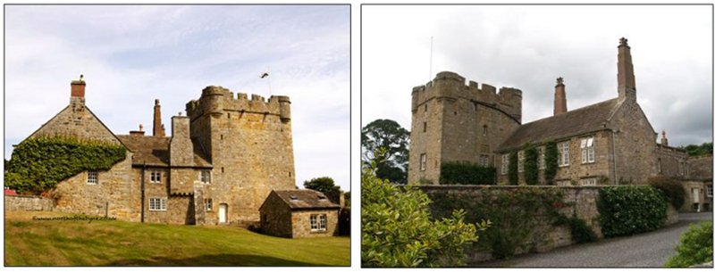
HALTON CASTLE TOWER
The quiet hamlet of Halton has a
castle, an old church and a Roman
fort. Halton Tower is of fourteenth
century date. It is four storeys in
height (including the basement). In
the fifteenth century a manor house
was erected on the north side of the
tower, and in the seventeenth century
a Jacobean house was built on the east
side.
The township lies on the Roman wall,
adjacent to Watling street, 5 miles NE
of Hexham. Acres, 798. Pop. 45.
Houses, 8. Halton Castle, ½ a mile S
of the Roman wall, belonged to the
Haltons; passed to the Carnabys;
belongs now to Sir E. Blackett;
consists chiefly of stones taken from
Roman buildings; and is a massive
square tower, with corner turrets. A
Jacobean farm house is attached to it;
and has some Roman mouldings and a
weathered sculpture, which probably
was part of a sepulchral slab. A small
old church is near the castle, and
appears, like the castle, to have been
built chiefly of Roman stones.
Halton-Chesters, on the Roman wall,
was the station Hunnum, occupied by
the Ala Sabiniana; comprised an area
of 4¼ acres; but is now so obliterated
that even an antiquary who has not
been forewarned, might pass through it
without recognising it; yet, so late
as 1827, when the last portion of it
was subjected to the plough, was found
to contain numerous substructions of
very careful masonry. The chapelry
includes also Halton-Shields township,
and is annexed to the vicarage of
Corbridge in the diocese of Durham.
Halton Castle is surrounded by
beautiful gardens and the three
buildings stand in a very pleasant
situation unlike so many border holds.
|
|
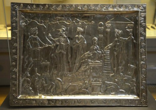
THE CORBRIDGE LANX
This magnificent silver platter
measuring twenty inches by fifteen
inches was found by nine-year old
Isabel Cutter in the bank of the River
Tyne at Corbridge, near Hadrian's
Wall, in February 1735. It is probable
that gradual erosion of the river bank
was washing out part of a fourth-
century silver hoard, as other vessels
were found there on various occasions
between 1731 and 1760.
Corbridge (Corstopitum) was a Roman
garrison town.The scene shows the god
Apollo at the entrance to a shrine,
holding a bow, his lyre at his feet.
His twin sister Artemis (Diana), the
hunter goddess, enters from the left,
and the helmeted goddess with her hand
raised to indicate conversation is
Athena (Minerva). The two female
figures in the centre are less
obvious. The entire scene is clearly a
shrine of Apollo. The Greek island of
Delos was the birthplace of Apollo and
Artemis, and Athena was also
worshipped there. If the Delian shrine
is depicted then the older woman
sitting spinning may be Leto, the
mother of the twins, and the standing
woman her sister Ortygia, who was
transformed into the island of Delos.
In the foreground stands an altar
flanked by Artemis's hound and fallen
stag and a griffin, a mythical beast
associated with Apollo.
The decoration of the platter and its
style indicate a fourth-century AD
date. Its place of manufacture is
unknown but may have been a major city
in the Mediterranean, North Africa or
Asia Minor. Ephesos has been suggested
because of its links with the cults of
Artemis, Apollo and Leto. Though no
other piece has survived, some were
sketched or described when they were
originally found. At least one of the
lost objects bore Christian symbols.
We can compare the treasure with the
Mildenhall treasure where high-quality
pagan decoration is combined with a
few Christian references.
The Latin term lanx (tray) was used
for vessels of this shape by
eighteenth-century scholars.
|
|
HALTONCHESTERS FORT
The Roman fort near Halton is called
Haltonchesters (in Roman times ONNUM
or HUNNUM). It covers five acres and
is divided in two by the modern road.
It was garrisoned by a cavalry
regiment called the Ala Sabiniana.
From Corstopitum it is distant about
two and a half miles. It guards
Watling Street which traverses the
valley immediately beneath it.
A portion of a monumental slab, now in
the Museum of Antiquities in Newcastle
upon Tyne, dates the building of the
fort to between 122 A.D. and 126 A.D.
At a later date an extension was built
on to the south west side giving the
fort an unusual L plan.
|
|
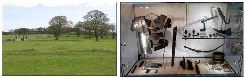
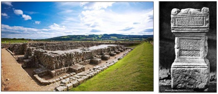
ROMAN STATION (CORSTOPITUM)
The Roman site at Corbridge lies half
a mile west of the village, It was
originally a fort and then a supply
base which flourished during the Roman
occupation of Scotland. Later it
became in the third and fourth
centuries an arsenal with a large
civilian settlement around it. The
original fort was probably built
during the governorship of Julius
Agricola (A.D. 78-84) who conquered
the north of England and the southern
part of Scotland. Remnants of this
Roman fort, with its earth rampart,
have been discovered. It was probably
garrisoned by a cavalry regiment from
Gaul called the Ala Petriana. A
tombstone in Hexham Church shows a
standard bearer of this unit. It
probably came from a cemetery at
Corbridge.
When Hadrian built the Roman Wall in
A.D. 122 the Corbridge fort seems to
have been replaced by the one at
Halton.
In A.D. 139 the camp at Corbridge was
rebuilt in preparation for the
invasion of Scotland, its position on
Dene Street making it an important
supply base. But its period of
greatest importance came when Severus
in A.D. 208 started his Scottish
campaign and Corstopitum became the
supply base for the whole eastern part
of the frontier. It fulfilled this
function until the Romans finally
abandoned the north of England.
The civilian settlement at Corbridge
was very important. Here lived many
wealthy merchants, as well as
craftsmen such as smiths, potters and
leather workers whose tools may' be
seen in the Museum. Besides catering
for the needs of the troops the large
civilian community was also engaged in
trade with the natives to the north of
the wall. Corbridge was also the
centre of a rich agricultural area and
nearby mines of coal, lead and iron
were exploited. The fort was probably
occupied until a few years before A.D.
400. What became of the civilian
population we do not know for certain
but within a century and a half the
village of Corbridge was in existence.
Excavations at the Roman site were
started in 1906 and a wealth of
material illustrating Roman life in
north Britain has been found,
including a Roman Altar pictured
above. The Museum exhibits many of
these discoveries while the remains of
numerous buildings can be seen on the
site which is under the control of the
Ministry of Works.
|
|
DILSTON CASTLE
Dilston Castle is a ruined 15th
century tower house situated at
Dilston, near Corbridge,
Northumberland, England. It has
Scheduled Ancient Monument and Grade I
listed building protection.
A three storey tower was built by Sir
William Claxton on the site of an
earlier pele tower in the 15th
century.
In 1621 the castle was acquired by the
Radclyffe family as a result of the
marriage of Edward Radclyffe to the
Dilston heiress. The Catholic
Radclyffes built a private chapel
adjacent to the house in 1616 ( the
chapel also has Ancient Monument and
Listed Building status). In 1622 Sir
Francis Radclyffe incorporated the
tower house into a new manor house,
which was to become known as Dilston
Hall.
A later Francis Radclyffe was a
supporter of the Royalist cause during
the Civil War and his estates
including Dilston Hall were
sequestrated by the Commonwealth. The
property was reverted to the family at
the Restoration. The 3rd Earlbegan in
1709 an ambitious programme to replace
the old house with a substantial
mansion. The new mansion was never
completed. The 3rd Earl James
Radclyffe took part in the Jacobite
uprising of 1715, was convicted of
treason and executed in 1716. The
ghost of his wife is reputed to haunt
the castle.
His brother Charles Radclyffe, also
involved in the rebellion, escaped to
France, but was (like his brother)
attainted of high treason. He returned
to support the later 1745 uprising,
was captured and executed in 1746 in
accordance with the sentence imposed
30 years before.
The attainder of the 3rd Earl would
normally have resulted in his property
(including Dilston) passing to the
Crown. However, he only had a life
interest under his 1712 marriage
settlement, so that his estates passed
to his 2-year-old son John, who died
aged 18. On his death in 1731, the
estates would have passed to his uncle
Charles Ratclyffe, who he was still
living abroad, but he had also been
attainted in 1716. After him, the
estates might have passed to his son
James Bartholomew Radclyffe, 4th Earl
of Newburgh, but an Act of Parliament
had been passed in 1731 amending
("explaining") an Act of Queen Anne
concerning naturalisation so as to
exclude the children born abroad to
attainted persons from being British
subjects. This prevented James Lord
Kinnard and any siblings from
inheriting (since foreigners could not
own land in England). Accordingly, the
estate would have reverted to the
right heirs of the 3rd Earl, but his
interest was also forfeit to the
Crown.
The 1731 Act directed that the Court
of Exchequer should sell the property,
but it was not sold. Instead, the
Greenwich Hospital Act 1735 directed
that Crown income from the estate
(after payment of various annuities
and the interest on mortgages) should
be employed to completing the building
of Greenwich Hospital. A further Act
was passed in 1738 to deal with
difficulties that had arisen under
this. Following the execution of
Charles Ratcliffe in 1746 (in
accordance with his 1716 attainder),
his Lord Kinnaird as his eldest son
petitioned the king, claiming to be
entitled the estate, but the
Commissioners of Greenwich Hospital
refuted his claim, because his right
had not been claimed before the
Forfeit Estates Commission and because
he was an alien. Being unable to
finance litigation over this, he asked
that the king should make financial
provision for him, and his mother
Charlotte Maria Radclyffe, 3rd
Countess of Newburgh (with his
approval) asked for provision for his
brother and three sisters.
Accordingly, a compromise was reached
that the Hospital Commissioners should
pay Lord Kinnaird £24000 and that
£6000 should be divided among his
siblings, else they would have all
become destitute upon the death of
their mother.
On the Countess' death in 1755, Lord
Kinnaird succeeded as 4th Earl of
Newburgh, and lived until 1786. The
5th Earl of Newburgh then applied to
Parliament for Restitution of the
estates, but was granted an annuity of
£2500, which he and his widow enjoyed
until the deaths in 1814 and 1861
respectively. The Hospital's revenue
from the estates had risen by the
1780s to £15000. The estate remained
in the hands of Greenwich Hospital
until the Commissioners until it was
transferred to the Admiralty Board
under Greenwich Hospital Act 1865. The
Board then sold the estate to
Wentworth Blackett Beaumont, 1st Baron
Allendale. Dilston Hall (left
uncompleted on the execution of the
3rd Earl) was used as the residence
for Greenwich Hospital's steward, but
the Commissioners ordered its
demolition in 1765, leaving standing
only the castle tower and the chapel.
A restoration of the buildings began
in 2001 and the castle was opened to
the public in 2003
In 2004, £220,000 was awarded to begin
work renovating the early 17th-century
bridge (The Lord's Bridge) near the
castle, as well as securing the
survival of the Jacobean range of
buildings with cobbled floor that
share the grounds with the castle.
The recent excavations have revealed
the remains of the demolished Dilston
Hall and its 17th-century service
range and have also found evidence of
medieval occupation of the site. The
restorations of the castle, funded by
the Heritage Lottery Fund, included
work on a new roof, repointing, and
the construction of a new floor,
constructed of timber, and a staircase
in the castle to access the upper
levels.The castle also shares its
grounds with a chapel, which is also
protected under the same historic
building laws as the castle.
The castle is situated on the same
grounds as Dilston College, a
residential college for young adults
with learning difficulties. The
college was originally a maternity
ward, until the Lord Rix changed it
into the current learning difficulties
college, having a daughter
with ‘learning difficulties’ himself.
|
|
TRANSPORT
Corbridge is bypassed to the north by the A69 road, linking it to Newcastle and Carlisle. It is also linked to Newcastle and the A1 by the A695 which passes about 1 mile (1.6 km) away on the south side of the River Tyne.
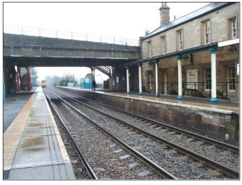
Corbridge railway station
The town is served by Corbridge railway station on the Newcastle and Carlisle Railway, also known as the Tyne Valley Line. The line was opened in 1838, and links the city of Newcastle upon Tyne in Tyne and Wear with Carlisle in Cumbria. The line follows the course of the River Tyne through Northumberland.
Passenger services on the Tyne Valley Line are operated by Northern Rail and First Scot Rail. The line is also heavily used for freight.
The railway station is about 1 mile (1.6 km) away on the south side of the River Tyne.
|
|
|
|
|
|