|
|
Newcastle Place Names
|
The City of Newcastle
No one knows when people first began
to settle in the place we know as
Newcastle. There is evidence that
people lived in the north east of
England during the Mesolithic period
7000 years ago. By around 3500 BC they
started to live in settled
communities, clearing the forests,
tending livestock and building
religious monuments. By the time the
Romans arrived in the area, in around
80 AD, a Celtic tribe, known as the
Brigantes or upland people, The
Romans, under their commander Julius
Agricola, built a fort on the north
bank of a shallow gorge on the river
Tyne. They also built a bridge known
as Pons Aelius.
Being near the coast and so close to
the border with Scotland, Newcastle
has always been afrontier town. Over
the years it has seen many bloody
battles. Angles, Vikings, Normans and
Scots have all fought for control of
the area. It may have been these
warlike ancestors that made Tynesiders
tough. They have never been afraid to
serve their country when it was
needed, skilled Geordie seamen were
much in demand in Nelson's navy and
thousands of North Easterners laid
down their lives in the First and
Second World Wars.
The North East has produced more than
its share of inventors; men like
Stephenson, Armstrong and Parsons,
whose genius changed the world. Local
people have never been afraid of hard
workoast, and so close to the border
with Scotland,
engineering and shipbuilding, were
difficult and often fraught with
danger, but Tynesiders' pride and
determination earned them a worldwide
reputation for quality.
Over the years the people of the North
East have faced many challenges and
many hardships. Tyneside is still
going through immense changes today.
But one thing is sure Northerners are
survivors and they will always win
through in the end.
|
|
Medieval Newcastle
Medieval Newcastle begins with the building of the royal castle by William 1st, son, Robert, in 1080. There is no evidence of any earlier village around the site of the castle, although there were Anglo-Saxon settlements in the vicinity of Pandon and Monkchester (possibly around St. Andrew's church). The castle, of the motte-and-bailey type, was made of wood and earth, and the present stone Keep and castle walls were built between 1168 and 1179. Around this time fortress and the bridge built across the Tyne, on the line of the present Swing Bridge, there rapidly grew up a flourishing trading community and town.
The importance of legal privileges in medieval trading has already been noted, and Newcastle's rapid growth was as much due to its ¬gaining trading monopolies and efficiently enforcing them as to its location, port facilities and commercial enterprise. The ‘Laws of 1 Newcastle’, dating from 1100-1139, are the earliest evidence of these gains. The oldest surviving copy is a manuscript only 11 inches by three-and-a-half inches, to be found in the Public Record Office in London. It records and confirms the rights of the Newcastle burgesses: ‘No merchant, unless he be a burgess may buy (outside) the town either wool or leather or other merchandise, nor within the borough except (of) burgesses’, and ‘No one but a burgess may buy webs (cloth) to dye, nor make nor cut them’, together with other regulations, such as ‘If a plea arise between a burgess and a merchant, it shall be concluded before the third ebb of the tide’, and if a ship have put in at Tynemouth and wishes to depart, the burgesses may buy what they will’.
The medieval town grew up mainly on the higher ground to the north of the Castle, with the markets around St Nicholas's church in the present Groat and Bigg markets, though buildings followed The Side down the steep descent to the bridge and marshy shore of the river. Growth to the east was restricted by the steep ravines of two small rivers no longer visible. The Lort Burn rose in the Leazes and descended down the line of Grey Street and Dean Street, entering the Tyne at the Sandhill, then an unreclaimed margin of the river. Further east Pandon Burn ran down from Barras Bridge to enter the Tyne at the east end of the present Quayside. The topographic problems faced by medieval Newcastle can only be recaptured today by walking the old town on foot. Early growth was confined to the west side of the Lort Burn. By 1175 Westgate was a main street, and around St. Andrew's church Newgate Street was growing. During the 13th century the town expanded rapidly.
In 1220 a new parish of St.John's,Westgate, was carved out of the existing St. Nicholas's and St. Andrew's parishes,
and by 1290 there was a continuous line of properties from St. Andrew's through the Bigg Market to St. Nicholas's.St. Bartholomew's nunnery had been established beside this road in the 12th century, and in the 13th century a number
of friaries came to Newcastle: the Dominicans 1 (1261), Franciscans (1274), Carmelites (1278), and Austins (1290). The Vicas Peregrinorum' or Pilgrim Street, running down the east bank of the Lort Burn from the Franciscan friary to All Hallows (as All Saints was then known) and the Sandhill, is first mentioned in the 13th. century. Between this street and the main markets around St. Nicholas's, two paths crossed the Lort Burn at High Bridge and Low Bridge, still to be found today. Lower down, almost at The Side, the Painter Heugh (now a derelict alley off Dean Street) went down from Pilgrim Street to the Lort, and is mentioned in 1373. Historians such as Bourne assure us that the river ebbed and flowed as far as Low Bridge and even High Bridge. Certainly the lower parts of the Lort Burn to the foot of The Side were navigable. By 1337 though, the Sandhill was being reclaimed from the river, for there were building plots on it, and in 1393 a royal proclamation cleared the Sandhill of stalls and merchandise for use as an open space, It was on the Sandhill that several of the noblemen on the wrong side at the Battle of Hexham in 1464 were beheaded.
East of the town was the industrial village of Pandon, where fullers, dyers and brewers lived. In 1269-70 a fuller
called John le Surays lived in Crosswellgate (now Pandon Street), and in 1278 the inhabitants petitioned the King
because the Carmelite friars were monopolising Crosswell spring, which the dyers and fullers needed for their trade, and the merchants and sailors for drinking. The Pandon burn was crossed by Stockbridge, and this and Cowgate recall the location of the town's byres for the cows grazed on the Town Moor. Although much of Newcastle's trade was carried in foreign ships, there was clearly a small shipbuilding industry in the town, for in 1294 Newcastle was one of the ports ordered to build a galley for Edward I's fleet. The records of the galley's construction indicate that the vessel, designed to take up to 120 oars, was probably built in Pandon, and certainly docked there after being damaged during 'trials' up the coast to Bamburgh. In 1299 Newcastle formally annexed the suburb of Pandon. Between the Sandhill and Pandon, below All Hallows church, the Quayside was gradually being reclaimed from the river, and the dense, narrow lanes or chares began to be built. These were, however, very liable to flooding and in Edward Ill's reign 140 houses at the Pandon end were destroyed, and about 67 people drowned. As the port grew the areas around the Sandhill and Quayside, the lower town, became more important in the late middle ages.
The growth of the town was reflected in its ranking fourth in wealth in 1334, behind London, Bristol and York.
After the plague the 1377 poll tax ranked it twelfth, with 2,647 taxpayers. An indication of its status is that Henry III
had set up a mint in the town in 1249. Walls for the expanded town were begun about 1265, when a special murage toll
was imposed on trade. The Newgate wall and stretch to the south west were built by 1285, and in the south east the
wall had to be re-directed to encompass Pandon. The final curtain wall, over two miles long with seven gateways, 19
towers and 30 turrets, was not completed until after 1318, but the impetus of the Scottish wars forced the townsmen to
complete the outer ditch or King's Dykes a few years earlier. Around Newgate this ditch could be flooded. Along the
Quayside the wall ran from Sandgate to the Sandhill, with 17 watergates giving access to the river.
As the town and its commerce expanded, so it began to press for some municipal independence. During the 12th century the town was controlled by a royal bailiff, but in 1170 and 1213 it managed to negotiate some financial
and judicial independence in exchange for annual payments to the King, set at £100 after 1213. Daniel, son of Nicholas, was chief bailiff in 1216 and is usually regarded as the first mayor, though royal approval for the title only
came in 1251. We know nothing of the selection procedure for the mayor, but both the office and the town were
controlled by the leading merchants. Until 1300 two families, the Scots and Carliols, monopolised the office, but after 1300 a number of the other leading wool merchants appear, such as Peter Graper, Richard Acton, John Denton, Richard Galloway, and Robert Angerton. Richard of Embleton held the office 23 times between 1305 and 1332.
Under the 'Laws of Newcastle' there were no legal or trading distinctions amongst the burgesses. However, in 1216
King John had allowed the formation of a merchant guild in Newcastle, and the leading exporters and importers began
to gain control of all trading as well as politics. In 1305 a group of 'poor burgesses', claiming that the rich burgesses 'by sinister collusion among themselves' were stopping them using their trading rights as burgesses, preventing them
selling wine, cloth or groceries, or dealing in hides and wool. For the rich burgesses Nicholas de Carliol claimed that the 1216 grant gave exclusive rights to the guild, but he could prove no legal basis for this, and the poor burgesses won their case. It was, however a temporary victory.
A crisis occurred in the control of town government during the 1340s, centred on John of Denton. Denton, a wool exporter and war-contractor, was mayor in 1333, 1336-7 and 1340, and alienated many in the town by his profiteering, opportunism and suspected corruption. In 1337 all the jurors on an enquiry into the value of land were his relatives, and they implied that certain plots, which really belonged to the Corporation, were owned by the King, who promptly rented them to Denton, including 'the Mydding Place' on the Sandhill. In particular Denton clashed with the Galloways and Scots. At his re-election in 1341, one group of burgesses elected a rival candidate and seized the town gates, and there was rioting. The King took over and ordered an enquiry.
This gave the lesser burgesses a chance to act, and they suggested a new charter, which was adopted in 1342. This included weekly statements of the town accounts and a formal election system to stop disputes. Between 1308 and 1342 12 companies or 'mysteries' had been created within the burgesses: the merchant companies of the woollen merchants (drapers), corn merchants (boothmen), and silk merchants (mercers), and nine lesser crafts companies including the skinners, butchers, smiths and bakers.
The election procedure was intricate: each mystery elected two men, and the 24 elected four. These four co-opted another eight, and this group of 12 then elected another 12, and this final 24 elected the mayor! It was clearly a system highly susceptible to pressure and influence. In 1343 Galloway and his supporters won, and in 1344 they arrested Denton on a charge of aiding the Scottish army. Denton refused to plead, knowing the jury was rigged, and died in jail. Edward III reacted by taking over the town, and setting up a hunt for Denton's 'murderers'. In the summer of 1345 he restored the town's rights, allowing the election of Robert Shilvington, but, insisted on an even 'safer' election procedure. Now the mayor and four bailiffs elected seven men, and the group of 12 elected four. These four proceeded as in the 1342 system, but the new rules even more effectively perpetuated the ruling group.
The 1342 system was restored in 1371, but it made no dent in the oligarchic control. In 1400 the town became an independent county with its own sheriff.
Great merchants like Robert Rhodes, Robert Whelpington, and the Harding dynasty dominated the town in the 15th century. Greatest of all was Roger Thornton, whom later centuries portrayed as the Dick Whittington of Newcastle. In the words of an old verse:
'At the Westgate came Thornton in
With a hap, and a halfpenny, and a lambskin.'In reality Thornton came from a landed family, probably in North Yorkshire, but he did rise to be a leading merchant, exporting wool and investing in Durham lead-mines, and mayor of Newcastle 10 times between 1400 and 1425. His reputation lived on because of his benefactions to the town, notably the Maison Dieu, built on the Sandhill in 1412 for 13 poor men and women, and later granted by Thornton's son for town use for wedding receptions. The east end of this building survived as part of the Guildhall until 1823. (Similarly, Rhodes probably provided the fine steeple of St. Nicholas's that we still see.) Roger Thornton lived in Broad Chare by the Quayside, and his will in 1429 showed the extent of his property. He had a main London house called Tannersheld in Cheapside, several estates In Northumberland (especially Netherwitton, where his family survived into the 18th century), and numerous houses and plots all over Newcastle. Thornton was buried in All Hallows, with a huge monument of which the magnificent Flemish brass plate with its engraved figures still survives.
Disputes over the trading rights of burgesses continued. In 1438-9 there was an agreement that all burgesses had the right directly to purchase from ships and strangers for their own use (as agreed in the 1342 charter), but not to re-sell, and in 1477 Henry Redpeth, a tailor, was fined 4s. 4d. (22p) for retailing lint and other goods. After a further dispute the royal Star Chamber in 1516 confirmed the trading monopoly of the merchant companies (which had grouped into a Merchant Adventurers' Guild), and altered the election system so that the four men nominated by the 24 had to be former mayors, aldermen or sheriffs, so further strengthening the ruling group. A number of new companies were formed in the 15th century to represent various town crafts and control apprenticeship and behaviour. So in 1442 a Barber-Surgeons company was incorporated to regulate shaving and primitive medical practices: no foreigner (including Scotsmen) was to be taken as an apprentice, no member or apprentice should shave in the town on a Sunday, nor should they interfere with each other's patients. At the annual procession of all the guilds on Corpus Christi day, this company had to meet at Newgate and after the procession perform the Miracle Play of the 'Baptizing of Christ'.
|
|
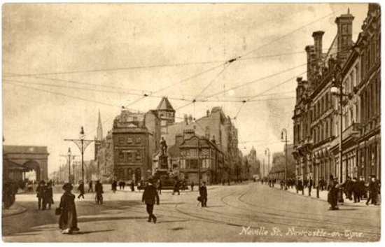
Neville Street
Neville Street was built in 1835 to
help people get from Collingwood
Street to the Cattle Market.
Two towers from the old town wall
stood here, and one, Neville Tower,
gave the street its name. Neville
Tower was named after the Earls of
Westmorland whose seat was at Raby
Castle in County Durham.
They also had a town house,
Westmorland Place, which stood on the
site of the Literary and Philosophical
Society.
Neville Street was widened in 1847 –
1848 to make room for the Central
Station.
|
|
BLACKFRIARS (pictured above left)
In the early thirteenth century a
religious order of Dominican Friars
settled in London and Oxford. By 1239
they had arrived in Newcastle. They
were called Black Friars because of
the colour of the mantles and cowls
they wore. Religious houses offered
accommodation for travellers, and
those in Newcastle often had royal
guests. Edward II and Queen Isabella
stayed at Blackfriars.
Newcastle had many other religious
orders. There was the Benedictine
Monastery of St Bartholomew (which
stood on the site now occupied by
Grainger Market and after which Nun
Street is named), as well as Grey
Friars (Franciscans), Austin Friars,
and White Friars (Carmelites).
When Henry VIII broke with the Roman
Catholic Church, he dissolved the
monasteries.The members of the
religious houses were evicted and
their land sold off. Newcastle
Corporation bought the house ot the
Black Friars, and, in I552 leased the
building to nine of Newcastle's craft
guilds. Upper rooms were used tor
guild meetings and those on the ground
floor were let out as residential
property.
THE COOPERAGE (pictured above right)
The Cooperage was originally a
sixteenth century merchant's house
which, according to tradition was
built from timber taken from a sunken
ship. Because the building stands
near the old town wall, at the foot of
Castle Hill, there was no room to
extend it outwards. In stead, a new
storey was added every hundred years
or so. Some of the bricks used in the
building are Dutch and were probably
used as ballast on ships returning to
the Tyne.
In 1863, an old-established cooper (or
barrel maker) moved into the building.
Barrels were used to transport all
kinds of goods - not just beer and
wine, but things like butter and fish -
so the business flourished on the
quayside until 1973, when the building
was converted into a pub and
restaurant.
|
|
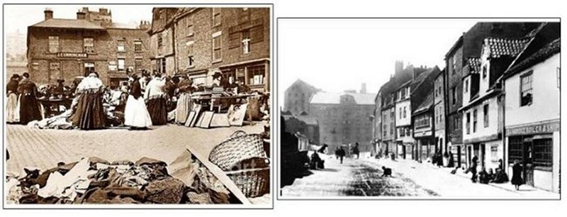
PADDY'S MARKET (pictured above left)
Paddy's market was a second-hand
clothes market which was held in
Newcastle's Milk market. In 1831
Thomas Oliver described "a sale of old
clothes laid on straw upon the
street." It probably got its name
because many Irish immigrants were
involved in buying and selling old
clothes.
Paddy's Market continued well into the
second half of the 20th century, with
clothes laid on tables and on the
ground and hung on the remains of the
old town wall. The name has even
entered our language, being used to
describe an untidy room.
SANDHILL & SANDGATE(pictured above
right)
The name Sandhill dates back to at
least 1310, and takes its name from
the heap of sand that was exposed when
the tide was out. Fish, herbs, bread,
cloth and leather were sold here, and
it was also a venue for bonfires, bull-
baiting, plays and public executions.
By the 17th century, the street was
very fashionable and the home to many
wealthy merchants.
Sandgate runs just above the Quayside.
It was once crammed with tiny, dark,
semi-derelict dwellings, which were
mostly the homes of keel men and
sailors. Because of its overcrowding
(according to one writer several
thousand people lived here in 1736)
and slum conditions, the area
attracted the attention of John
Wesley. In May 1742 he "Walked down to
Sandgate, the poorest and most
contemptible part of town."
In front of 1500 local people he sang
the 100th psalm and preached a sermon.
He returned that evening to find the
slope to the Hospital "covered from
top to bottom with poor folk of
Sandgate ready to tread me underfoot
out of pure love and kindness."
By 1827, the lanes of Sandgate were
still dark, narrow, badly paved and
full of noisy, drunken, brawling,
blaspheming men, women and children.
Living conditions were not improved by
the tanneries, limekilns, shipyards
and other manufacturing in the area,
but by the turn of the twentieth
century, much of the slum housing had
been demolished.
|
|
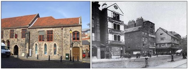
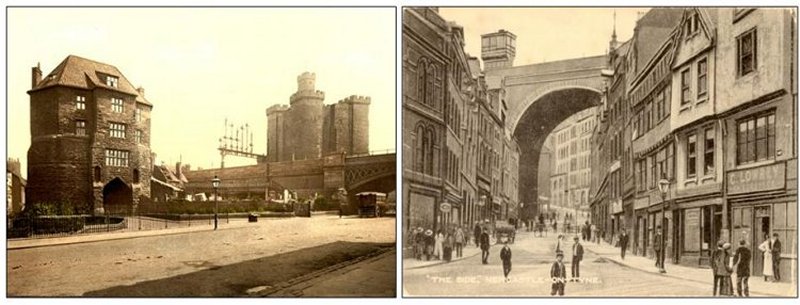
THE BLACK GATE (pictured above left)
The Black Gate was the last part of
the castle's defences and was built
between 1247 and 1250.
As the political situation changed,
and there was less chance of the town
being attacked by the Scots, the
castle fell into disrepair. The Black
Gate was converted into a house in
1618 by the addition of a roof and
windows. By 1636 it was being used as
a pub, run by landlord John Pickells,
whose name can still be seen on one of
the walls.
Other tenants in the 17th century
included London merchant called
Patrick Black and his wife Barbara. It
may be that the Black Gate was named
after them.
The Black Gate was separated from the
Keep in the mid-19th century, when a
railway viaduct was built between
them.
THE SIDE (pictured above right)
Before Dean Street was built in the
1780’s, the steep, narrow street
called Side was the main road from the
old Tyne Bridge to the higher parts of
town. According to historian John
Brand, Side got its strange name
simply because it is a route down the
side of a hill.
Admiral Collingwood, one of the heroes
of Trafalgar, was born in Side in
1748.
A bust over one of the doors of
Milburn House marks his birthplace. He
went to sea aged 13, and spent most of
his life on board ship.
When Nelson was killed at Trafalgar,
Collingwood took command of the
British fleet. A terrible storm blew
up after the battle, but Collingwood's
skills as a commander meant that no
British ships were lost.
|
|
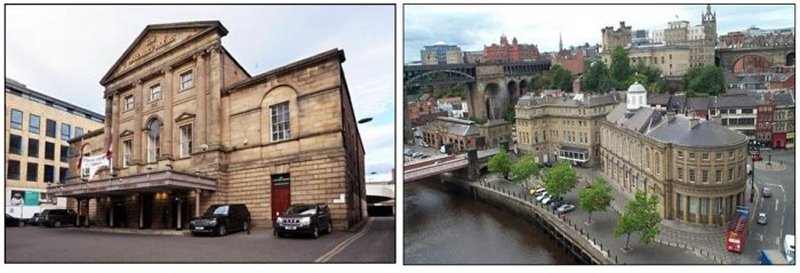
THE OLD ASSEMBLY ROOMS (pictured above left)
Newcastle Assembly Rooms on Westgate Road first opened to the public on 24 June 1776. The building, which cost £6,700, was intended to be the meeting place for Newcastle’s high society.
Sir Mathew White Ridley with Miss Aliwood and Sir William Loraine with Mrs Bell opened the first assembly. "Periwigs, powder, and patches; full skirted coats, ample hoops and silver buckles" graced the grand rooms, as elegant people emerged from carriages to join in the merriment.
Over the years the Assembly Rooms have played host to some magnificent occasions.
A ball was held here to celebrate the visit of the Duke of Wellington to the town in 1827.
On another occasion Charles Dickens and his amateur theatrical company performed three playlets, and there were concerts by Strauss, Liszt, Rachmaninov and Rubenstein.
Edward VII, George V, George VI and Queen Elizabeth all visited the Assembly Rooms.
THE GUILDHALL (pictured above right)
The Guildhall was once a centre for administration and justice in Newcastle, and the building still contains a terrifying spiked dock and other
court fittings from the late 18th and early 19th century.
The Guildhall was designed by Robert Trollope and opened in 1658.
The colonnade at the east end of the building once surrounded the fish market which was added by John Dobson in 1823.
According to one story the fishwives hated the new market until they realised how much warmer and more comfortable it was than their old stalls which had been dotted about the quayside.
They sent Dobson a present of fish for his Christmas dinner. When a new fish market was built in 1880, the colonnaded area was enclosed and made into a newsroom.
|
|
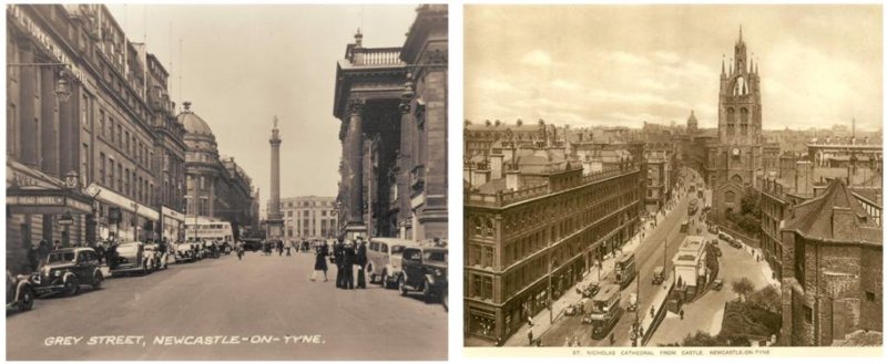
GREY STREET (pictured above left)
Grey Street formed part of Richard Grainger's redevelopment of Newcastle in the I830s.
Old buildings were swept away and e1egant new buildings replaced them with amazing speed. One of the buildings that was demolished to make way for Grey Street was the Georgian Theatre Royal which stood on Mosely Street. Its owners were offered compensation of £500 and promised a new, larger and more prestigious theatre.
They were probably not disappointed. The new Theatre Royal, designed by John and Benjamin Green and opened in 1837, was described as "one of the largest and most beautiful outside of London ... one of the greatest ornaments to Grey Street."
The new development was a huge success, and in the early 1840s the traveller, William Howitt, claimed 'Newcastle is now one of the most remarkable towns of the British Empire."
Grey Street has been singled out for particular praise. W E. Gladstone called it "England's finest street" and Pevsner described it as "one of the best streets in England'.
Grey Street was originally called Upper Dean Street, but was renamed in 1836 when the town decided to honour Earl Grey of Howick Hall in Norrhumberland. As Prime Minister, his work on the Great Reform Act ended some of the worst abuses of our political system extended the vote to male property owners. Grainger was asked to leave a space for a monument at the top of Grey Street.
St NICHOLAS STREET (pictured above on the right)
St Nicholas Street was built in 1851 to provide access to the High Level Bridge.
It runs past (and takes its name From) St. Nicholas' Cathedral. The First Church of St Nicholas was founded on this site by Osmund, Bishop of Salisbury, in 1091.
It was destroyed by Fire in 1216, rebuilt in 1353 and was made a Cathedral in 1882.
When Newcastle was besieged by the Scots during the civil war, the Scottish commander, the Earl of Leven, declared that he would destroy St Nicholas' Famous lantern tower unless the town surrendered to him.
Newcastle's Mayor, Sir Jon Marley, had the idea of putting some Scottish prisoners at the top of the tower where Leven could see them. The Earl could not kill his own troops so the tower was saved.
When King Charles I was held captive in Newcastle, he attended a church service at St Nicholas. The Scottish Presbyterian minister taking the service called for Psalm 52:
"Why dost thou tyrant boast thyself. thy wicked works to praise”.
Unperturbed by this personal attack, Charles immediately called For Psalm 56 instead, and the loyal people of Newcastle joined with him to sing:
"Have mercy, Lord on me I pray, For man doth me devour”.
St Nicholas Street was, for many years the site of Newcastle's main Post Office. Its Frontage was preserved during recent redevelopment.
|
|
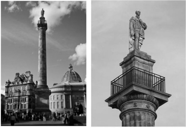
Grey's Monument (pictured above)
The 133ft high column which supports Grey's monument was designed by Benjamin Green and completed in 1838.
Then the 13ft statue of Grey, sculpted in London by Edward Hodges Baily, was winched into place to the sound of the town's church bells.
Inside the column, 164 stone steps spiral upwards to a railed platform with spectacular views.
There is also a secret buried in the column's foundations. This is a large glass container which holds the original plans for the monument, a list of subscribers who contributed its construction and a collection of medals and gold and silver coins.
In 1941 Grey's monument was struck by lightning and the Earl's head was shattered. Because of material and labour shortages during the Second World War, a replacement could not be made immediately, but in 1947, Roger Hedley, son of the painter Ralph Hedley, sculpted a new head.
|
|
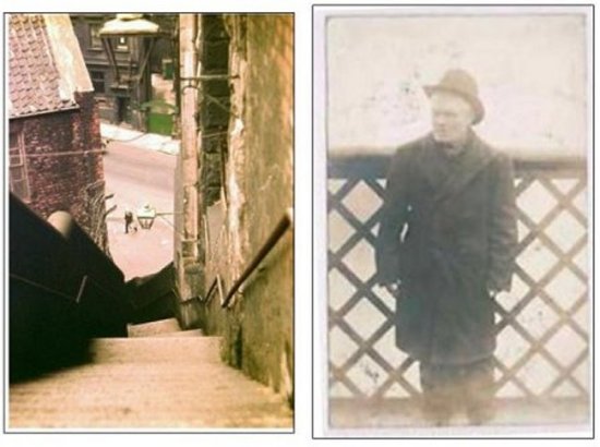
DOG LEAP STAIRS (pictured above left)
The Dog Leap stairs lead from Castle Garth, an open area beside the Black Gate to Dean Street at the foot of Side.
No one really knows why they got their strange name. Before they were widened in 1822, they were so narrow that a dog could leap across them. The name could also be derived from me term "dog- loup” which is a narrow strip of land, resembling the shape of a dog's hind leg, running between houses. The twist in the stairs does make them look rather like a dog's leg.
TOMMY ON THE BRIDGE (pictured above right)
Tommy on the Bridge was a well known character on Tyneside. He was a blind beggar who stood on the Swing Bridge, always in exactly the same spot - on the boundary line between Newcastle and Gateshead so that neither authority could arrest him for vagrancy.
His real name was Thomas Ferens and he was thought to have been born in 1842 in the Close. During a severe winter, on New Year's Day 1907 he collapsed in the snow at the southern end of the bridge and died.
|
|
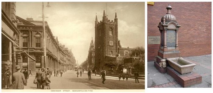
GRAINGER STREET (pictured above left)
Grainger Street, as its name suggests, is another part of Richard Grainger's 1830s redevelopment of Newcastle. One local writer described it as "handsome in its architecture but tame in comparison to Grey Street."
Grainger's work had an enormous influence, not only on the physical appearance of Newcastle, but also in the way outsiders perceived the town. It was a remarkable achievement for the son of a day labourer.
Born in 1797, he lost his father at the age of 12 or 13. At 14 he was apprenticed to a
master carpenter and began to learn the basics of the building trade.
Over the next 20 years he became the most influential builder and property developer in the North East. The writer W Lawson observed: "Few men have accomplished so much as he by way of improving the physical aspect of their native town”.
THE GRAINGER MEMORIAL FOUNTAIN (pictured above right)
Richard Grainger died suddenly on 4 July, 1861 from "disease of the heart':
In 1868, a letter in the Daily Journal criticised the town for not erecting a monument to him similar to those to Earl Grey and George Stephenson. Grainger had to wait until 1892 for his, much more modest, monument.
His daughter Rachel left instructions in her will for a public fountain and water trough in memory of her father and mother. It was originally in Neville Street but was moved to Waterloo Street in the 1950s
|
|
PINK LANE (pictured above left)
Chares and much of the layout of Newcastle's Quayside date from medieval times. At one point, there were 20 chares in Newcastle. After the great fire of Newcastle and Gateshead in 1854, a number of the chares were permanently removed although many remain in existence today. Chares also are still present in the higher parts of the city centre.
According to "Quayside and the Chares" by Jack and John Leslie, chares reflected their name or residents. "Names might change over the years, including Armourer's Chare which become Colvin's Chare". Originally inhabited by wealthy merchants, the chares became slums as they were deserted due to their "dark, cramped conditions". The chares were infamous for their insanitary conditions - typhus was "epidemic" and there were three cholera outbreaks in 1831-2, 1848-9 and finally in 1853 (which killed over 1,500 people).
Other than on the riverside, there are a number of chares in existence in the higher parts of the city: Among them lies PINK LANE - a very narrow alley stretching Clayton Street West and Westgate Road. It is best known for containing the excavated foundations of Gunner Tower, part of the ancient Newcastle town wall. I have been unable to find out the origins of name Pink Lane.
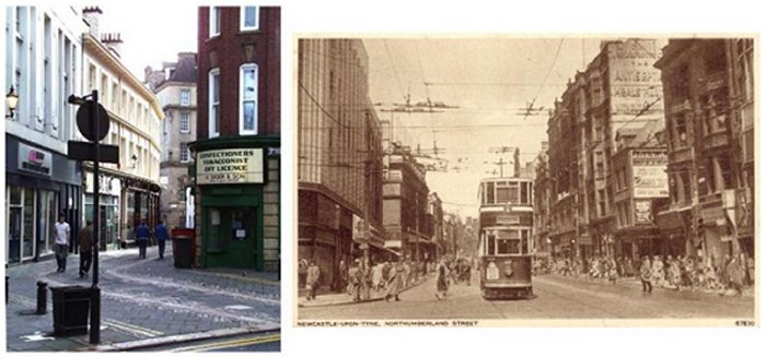
NORTHUMBERLAND STREET (pictured above right)
The suburbs of Pilgrim Street were ruined during the civil wars in the reign of king Charles but they are now one of the pleasantest and best-built parts of the town.
The continuation of Pilgrim Street is properly named NORTHUMBERLAND STREET (named after the County) and since the old gate was removed, these two long streets have a most airy, light, and elegant appearance. At the foot of Northumberland Street, a new and handsome street is now forming, called Blackett Street and which terminates at the north end of Newgate Street. This street is 70 feet broad; and the houses are building after a commodious and elegant plan, furnished by Mr. Dobson, architect.
The south side of the street terminates on the east by a new Presbyterian chapel. On the north side, a handsome square is forming, with a shrubbery in the centre, 192 feet broad, and which is to be enclosed by a low stone wall and ornamental iron railing. The street round the square is to be 62 feet wide; and each side will contain ten houses, with tasteful stone fronts. The front of this square is laid out for twelve dwelling-houses; and if the beautiful portico and other architectural ornaments which appear in the design of the centre buildings be executed, the effect of the whole will be greatly heightened; and this square will be one of the proudest monuments of the taste and spirit of the corporation in modern times.
|
|
The Haymarket
There is a long tradition of markets in Newcastle. Some of the historical markets gave their names to parts of the city centre, such as HAY MARKET and Bigg Market (bigg was a form of barley); other markets were the Herb Market, the Cloth Market and the Butter Market.
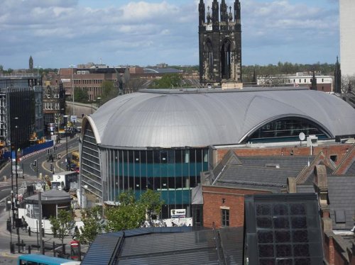
Haymarket is an area in the north of the city centre of Newcastle upon Tyne, England. The area functions as a public transport hub (pictured above) with Eldon Square bus station, Haymarket bus station and Haymarket Metro stationlocated next to each other.
Although mainly a commercial area, Haymarket features the facades of Newcastle University, Northumbria University andNewcastle Civic Centre. It is also the location of the Church of St Thomas the Martyr, a prominent city centre landmark.
The grounds also include various war memorials including The Response, 1914 by Goscombe John, described by Alan Borg, a former Director General of the Imperial War Museum as "one of the finest sculptural ensembles on any British monument.".
The main pedestrianised shopping street in the city, Northumberland Street, meets Haymarket at its northern end.
|
|
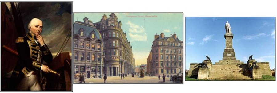
Collingwood Street
Admiral Lord Collingwood's presence is everywhere in North East England - on the names of streets, monuments and buildings.But who is this forgotten hero?
Most of us know the name Collingwood from walking down his street in Newcastle or past his imposing monument in Tynemouth. Admiral Lord Collingwood was a colossus of a man, but few remember his crucial role in Britain's naval history.
He fired the first shot at Trafalgar, and took over command of the British fleet after the death of his friend Nelson. But whilst Nelson's name has been immortalised, Collingwood's good name only seems to survive through his family tree.This modest man is largely a background player in most history books, yet his contribution was immense.
When his memorial was unveiled it was said that:
"He was a typical north countryman - never duly elated by success or depressed by failure, caring little for public applause".
Today Collingwood is celebrated on buildings and memorials around the North East.
Tracking down places with links to the great man is a bit of a treasure hunt.
Perhaps the most poignant monument to Collingwood is his statue at Tynemouth (pictured above right) which looks out to sea proudly.
|
|
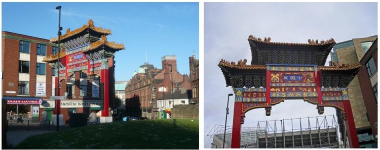
Stowell Street
Newcastle’s small Chinatown is centred on Stowell Street, home to many Chinese restaurants and a few supermarkets. While small compared to those in other cities it is worth a visit to get a feel for a different aspect to the city, to see the imposing Chinese gate, and of course to eat.
While there have been Chinese inhabitants in Newcastle for decades (it is after all a port city), and Chinese restaurants since the middle of the twentieth century, it was only in the late 1970s that Stowell Street acquired its first Chinese supermarket, swiftly followed by a number of restaurants. And it is relatively recently that the street and the immediate area around it have taken on the by-now expected trappings of a “Chinatown” – signs in Chinese, street lamps designed to look like lanterns, and of course an impressive entrance gate – in this case at the north end of Stowell Street, opposite St James’ Park.
This was built in 2004 by craftsmen in Shanghai. It is 11 metres tall and is flanked by two Chinese guardian lions and stands on St. Andrews Street, at the northernmost extent of the Chinatown, flanked by two Chinese guardian lions and facing St James' Park football stadium. Chinese new year celebrations are held here in February.
Other streets that form part of Chinatown and are worth exploring include Charlotte Square, Low Friar Street and others in the area around and to the south of Blackfriars.
|
|
Newgate Street
Newgate Street has clearly derived its name from the New Gate, that seems to have been erected on the site of Berwick Gate. It is now a broad and commodious street; and since the gaol, guard-house, and other obstructions have been removed, it has become one of the best streets in the town.
This place has been inhabited in very remote times, as may be inferred from the antiquity of the chancel of St. Andrew's church. Some writers conjecture that Monkchester was here; but as "most of the Saxon towns were on the very scites of Roman forts, from analogy we therefore suppose that Monkchester (of which in 1074 no vestige could be found) stood upon the grave of its parent, Pons Ælii."
The Main Guard-house was built on the south side of the gaol of Newgate, as represented in a wood-engraving. St. Andrew's church is contiguous to where this building stood. On the east side of the street, and opposite to the church, is a long, narrow street, called High Friar Chare, in contradistinction from Low Friar Chare, before noticed.
This street led to the monastery of Grey Friars, A long, dead, brick wall on the one side, and the town-wall mouldering into ruins on the other, occupied a considerable part of this street, and had a dreary appearance; but the east end of the north side is now terminated by a new Dissenting chapel, after which the south side becomes part of Blackett Street. The spacious meetinghouse of the Joiners' Company adjoins the chapel, and was for many years the principal ornament of the street. High Friar Lane branches off near the east end of the street, and also communicates with Pilgrim Street.
In Newgate Street, and a little below High Friar Street, there is a retired row of houses, which runs eastward, called Green-Court. On the opposite side, and at the bottom of the church-yard, there is a little ancient street, in which are three tanneries, named Darn Crook. It runs westward to the town-wall, through which a passage was made into Gallowgate in 1810, and dignified with the name of Heron Street, in honour of the late Sir Cuthbert Heron. In 1824, this passage was widened, by pulling down an old house that stood across it.
Mr. Young has also built a long row, consisting of about thirty houses, which runs from Darn Crook in a direction parallel with the town-wall. It is called Stowell Street; and the other side, containing about 7000 yards, is to be let for work-yards and mechanics' shops. An immense quantity of earth and clay has been led from this place, which is now reduced to a dead level; but the houses are thereby rendered less private, dry, and airy. They are very judiciously planned, consisting of four fire-rooms each, and are well adapted for families of a certain rank, whose convenience is seldom consulted by building speculators.
|
|
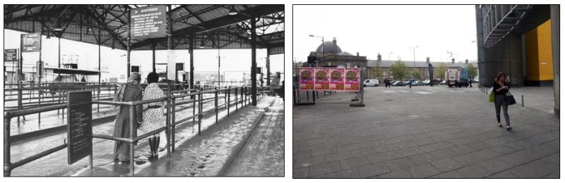
Marlborough Crescent
Marlborough Crescent station was built in the late-1920s and, for over half a century, served bus passengers travelling into North West Durham, Cumberland, Westmoreland, and all points west along the Tyne Valley, including Carlisle.
The oldest of the city’s stations, the last ticket to ride from there was issued in 1983. Today, there is no trace of it.
Between 1986 and 2000, the new, ground-breaking Centre for Life was built on the site of the station and a patch of derelict industrial land next to Newcastle Central Station.
Pictured on the left in 1977 two ladies waited forlornly for the next bus. Pictured on the right, the Crescent today.
|
|
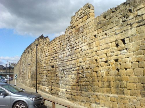
The Town Wall (pictured above at Orchard Street)
The Newcastle town wall is a medieval defensive wall, and Scheduled Ancient Monument, in Newcastle upon Tyne, England. It was built during the 13th and 14th centuries, and helped protect the town from attack and occupation during times of conflict. It was approximately 3 kilometres (2 mile) long, at least 2 metres (6.5 ft)thick, up to 7.6 metres (25 ft) high, and had six main gates: Close Gate, West Gate, New Gate, Pilgrim Gate, Pandon Gate and Sand Gate. It also had seventeen towers, as well as several smaller turrets and postern gates.
The towers projected out from the walls and were within bowshot of each other, so that attackers trying to scale the walls were exposed to fire from both sides (i.e., from the towers), as well as from the front (i.e., from the walls). The postern gates were provided for institutions, such as the Dominican Order of Blackfriars and the Hospital of St Mary the Virgin, so that they could access their property outside the walls. Even before the walls were complete, they were supplemented by an outer ditch, known as the King’s Dyke. The ditch was over 11 metres (36 ft) wide and 4.5 metres (15 ft) deep in front of the Herber and Morden Towers. It was completed by 1317.
The town wall was kept in good repair whilst there was a threat of invasion from Scottish armies, and the town was successfully defended on at least two occasions; but with the decline of the border wars between England and Scotland, the wall was allowed to deteriorate.
During the English Civil War, the Scots were able to breach the wall using mines and artillery. By the mid-18th century the wall had become obsolete and, as the town was redeveloped, large sections were demolished leaving only parts standing. The most substantial remains are the West Walls, on the western side of the city.
|
|
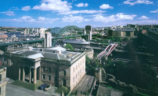
Our Geordie Tyne
The River Tyne stretches out to over 100 kilometres (62 miles) in length and is formed by the two rivers, the North Tyne and the South Tyne that both converge in Hexham in Northumberland, this area has thus been nick named ‘Waters Meet’ as the two rivers meet and join here.
During the 13th century the River Tyne was used as a main pathway for the export of coal up until the coalfields declined in the late 20th century. Although not used today there still lies some of the original structures that were used to load coal onto transporting ships.
During the 1940’s the River Tyne was well known for its thriving fish life and trout fish were regularly caught in their droves. It was very common for trout to be caught that weighed over 1.4lb’s, some weighing up to 4lb, once the word got out that fish of this size were being caught people travelled from far to try to catch a big fish for themselves and many competitions took place on the waters.
In the early 1950’s gravel digging took place on the River Tyne which left the flow of the water disrupted as there were large holes on the bottom of the river, this causes a large population of pike to build up which took over the salmon, it is reported that not many salmon were caught at this time at all. The gravel was removed in the late 50’s and a dam was created to help the run of salmon, after this the number of salmon started to increase over time.
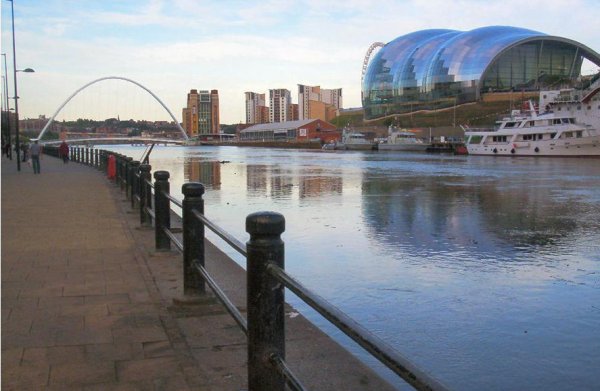
From between the Cathedral and the Castle there is a road that is most simply known as ‘The Side’, it was formerly a main road that led out of the city and now descends down to Newcastle’s Quayside. Still today remain fixed river crossings that first emerged in Roman times; today seven bridges all in close proximity to each other span the Tyne. The most prominent of these being the Tyne Bridge built in 1928, the symbol of the city, it bears a striking resemblance to Sydney Harbour Bridge (not surprising as both were designed by Dorman Long from Middlesbrough).
Immediately to the west of the Tyne Bridge is the hydraulic Swing Bridge that was erected in 1876 by Lord Armstrong for the purpose of larger vessels being able to reach his shipyards up the river. There are modern rails and roads that cross the river on the adjacent High Level Bridge, built by Robert Stephenson in 1849. Queen Victoria was one of the first passengers who crossed the bridge while she was promoting the railway revolution.
Protected by the towering castle, the Quayside became the commercial heart of the city; during the sixteenth and seventeenth centuries its half-timbered houses became the homes to Newcastle’s wealthiest merchants.
Just beyond the Tyne Bridge there is currently a modern regeneration of the Quayside is in operation. There are new riverside apartments, public sculptures, squares designed for pedestrian usage and a landscaped promenade that lead down to fashionable bars and restaurants centred on the Millennium Bridge, the globes first tilting bridge that can pivot to allow ships to pass. The Millennium Bridge allows for pedestrians to cross the Tyne and get to Gateshead Quays where you can visit BALTIC, the dramatic centre for contemporary art. The building is fashioned from a brick flourmill that was built in the 1940’s. The conversion of the building was huge; it is second only in scale to London’s Tate Modern. The art on show is not from a permanent collection; the galleries display many different exhibits from art exhibitions and local community projects. As well as the galleries, the BALTIC accommodates education workshops, artist studios, and a cinema and performance space. There are also two restaurants, one outdoors at river level with a nice outside terrace and the other on the roof with clear views of the Newcastle skyline.
Joining the BALTIC on the Gateshead side is The Sage Gateshead a huge billowing steel, glass and aluminium concert hall. The hall is home to the Northern Sinfonia and Folk works, an organization that promotes British and international traditional music.
|
|
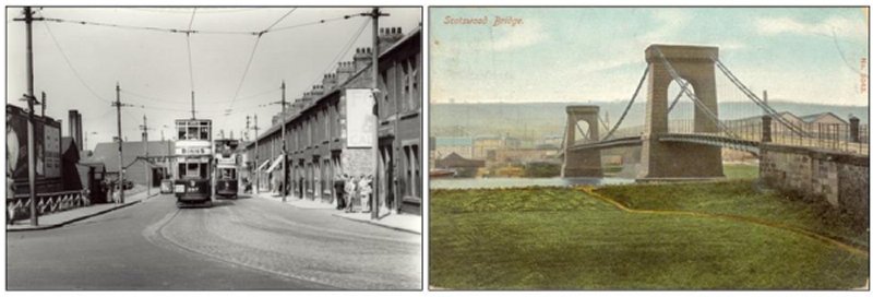
Scotswood Road's History
In the 1830s road and rail bridges were built across the T yne at Scotswood and for the first time north-west Durham was joined to Newcastle through Benwell and Elswick. Scotswood Road gradually evolved as the road Newcastle citizens could take to the Chain Bridge at Scotswood, leading to Blaydon and Shotley Bridge.
In 1847 William Armstrong bought two west fields below Scots wood Road in the Elswick estate and opened a factory to build hydraulic cranes. After the Crimean War in the 1850s his newly invented field gun was accepted by the government for use by the armed forces. By the 1880s he was building warships at Elswick for several countries, including Japan.
During the First World War the firm employed 57,000 men and 21,000 women at factories in Elswick, Scotswood and nearby. The population of Elswick between 1851 and 1901 had grown from 3,539 to 59,165. The Elswick section of Scotswood Road, one mile long, had a stretch of thriving shops and pubs opposite the factory. The whole area north from the Road to Westgate Road and beyond housing, churchess and shops. All were largely dependent on the economic health of Armstrong's.
Like other areas of heavy industry in the Depression between the wars widespread unemployment had catastrophic effects on a whole community. We have aimed to illustrate in this book some of the changes in the vicinity of the Road over more than a century. However, all was not gloom, there was a strength of the community there was spirit in adversity,
a liveliness, optimism and good humour which stemmed from the neighbourliness of the old streets when granny lived up the road and you could get anything you wanted on The Road.
Scotswood Road and the song Blaydon Races
The fame of Scots wood Road, Newcastle upon Tyne, today is mainly based on the fact that it is mentioned in the chorus of the song Blaydon Races. Although written in 1862 it has only been adopted as the Geordie anthem during this century. In various parts of the globe, when those who understand the Geordie accent come into contact, they can share a common heritage by singing a song about a journey by horse bus from Newcastle's Cloth Market to a race course on Blaydon Island on a Whit Monday, 1862. If they don't know the verses they can always belt out the chorus ending 'Gannin' alang the Scotswood Road to see the Blaydon Races'.
The popularity of the song stems from a book published before the First World War called Tyneside Songs. Local music hall singers revived the Geordie classics and Blaydon Races became a hit on newly introduced gramophone recordings. The chorus was taken up as a rallying cry by supporters of Newcastle United and soon their opponents began to learn the tune and identify it with the area. Soldiers in the First World War trenches sang it as a Geordie Tipperary to remind themselves of Collingwood Street, Armstrong's Scotswood Road factory and the Chain Suspension Bridge (pictured above) leading across to Blaydon.
The Scotswood suspension bridge eventually proved too narrow for the traffic it needed to carry and its increasing repair costs proved too much. After standing for 136 years, it was closed and demolished in 1967 after its replacement had been completed.
Only the song remains today because the races at Blaydon are a distant memory after being closed down by the police after a disputed decision in 1916. Blaydon Island, which was the site of the race course in 1862, was removed from the Tyne from 1865. In 1887 the Races were revived at Stella Haugh. Geordie Ridley performed the song for the first time at the Harry Clasper Testimonial Concert organised by local business men and John Balmbra at the Wheatsheaf Inn, Cloth Market on 5 June 1862. Rower Harry Clasper is accepted as the finest sportsman locally in the nineteenth century. Today the Bigg Market, adjoining the Cloth Market, brings fame to Newcastle, as the focal point of the 'partying city' of Britain.
|
|
|
|
|
|